|
|
|
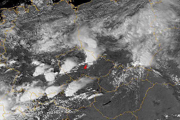
18 August 1986 1330 UTC NOAA 9 Czech Republic (northeast Bohemia) |
|
|
|
|
"Storm classics" - one of the most beautiful cases ever recorded, showing a "double plume" in the 3.7 µm image. Already the ch1+2+4 and strongly enhanced channel 2 images show a complex of plume-like structures, apparently originating above the storm core. Notice the shadows cast by these features at the anvil top - a manifestation of vertical separation of the plumes from the anvil top. Enhanced 3.7 µm image (ch3ref) shows something that resembles a "split plume". Or is this a wider plume of high reflectivity (shown dark) with another narrower, lower reflectivity (light grey) plume above it? The enhanced thermal IR image (ch4enh) is a very nice example of a "cold-U" and warm embedded area (inside "U"). Similar thermal IR features are considered as typical for severe storms (namely supercells) - and this one was indeed a strong one! (It was accompanied by a heavy wind damage and about 12 cm hail.) The ch3+4 composite image documents that the "source" of the plumes is located above (or within?) the warm embedded area and not above the coldest tops. This is very typical for most of storms with plumes. The detailed images shown above are zoomed (4x as compared to the original AVHRR pixel size) to show the finest storm top details. You can also click on the link below to display the ch1+2+4 image in larger scale (the image will be displayed in a new browser window, so just close the window when done): (the area shown on the large image is about 560x560 km, it is 2x zoomed as compared to the original AVHRR pixel size). |