
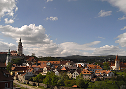
Ricoh GX100, interval ~ 2 seconds, speed 50x
20090101_Praha.mpg
(25.0 MB, 1024x672, MPEG1)
20090101_Praha.mp4
(22.0 MB, 1024x672, H.264 / MPEG-4)
Fireworks on the New Year's midnight above historical center of Praha (Prague Castle, Old Town and Malá Strana). Taken in continuous mode (CONT.) of the camera, with 2 second exposure of the individual images. Captured from a viewpoint at Petřín Hill, near Strahov monastery, Praha, Czech Republic.

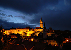
Ricoh GX100, interval 5 seconds, speed 125x
20090107_1250-1330utc_MalaStrana-Hradcany.mpg (16.4 MB,
1024x672, MPEG1)
20090107_1250-1330utc_MalaStrana-Hradcany.mov
(17.5 MB, 1024x672, H.264 / QuickTime)
20090107_1250-1330utc_MalaStrana-Hradcany.mp4
(13.1 MB, 1024x672, H.264 / MPEG-4)
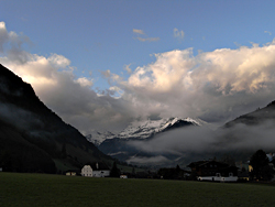
Winter romance in Praha. The uninteresting frontal cloudiness approaching from northwest was a good excuse to capture this beautiful winter scenery ...

Ricoh GX100, interval 5 seconds, speed 150x
20090319_1135-1420utc_Praha4.mpg (43.7 MB,
1024x656, MPEG1)
20090319_1135-1420utc_Praha4.mp4
(43.5 MB, 1024x656, H.264 / MPEG-4)
Typical weather behind a cold front ... from overcast to scattered cumulus clouds. Besides the very turbulent cumulus clouds, notice also the disappearance of the remains of snow cover (at the beginning of this sequence). The spring is knocking at the door ... Captured from the former radar tower at Praha - Libuš, northward direction.
Ricoh GX100, interval 5 seconds, speed 150x
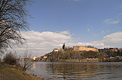
20090321_1109-1230utc_Cisarsky-ostrov-Vysehrad.mpg
(26.7 MB, 1024x672, MPEG1)
20090321_1109-1230utc_Cisarsky-ostrov-Vysehrad.mp4
(22.5 MB, 1024x672, H.264 / MPEG-4)
Thin cumulus clouds above Vyšehrad, and "stampede" of boats at Vltava River. Captured from Císařský ostrov (Imperial Island), Praha, Czech Republic.
Ricoh GX100, interval 5 seconds, speed 150x
20090324_1445-1545utc_Libus.mpg
(14.9 MB, 1024x672, MPEG1)
20090324_1445-1545utc_Libus.mp4
(17.0 MB, 1024x672, H.264 / MPEG-4)
Early spring snow squall, accompanying a line of shallow convective clouds. Structure of this belt of clouds can be seen best from the satellite imagery - e.g. the NOAA 15 image (red dot indicates the location, from which the sequence was taken - CHMI building at Praha - Libuš, view towards north), loop of Meteosat 8 images showing the Czech Republic region, taken at 5 minute intervals (13.5 MB, the red dot indicating not only the location, but also the period of the sequence), or other loop of Central Europe (Meteosat 8, 15 minute intervals, 8.6 MB), and finally a global view of most of Europe (Meteosat 8, 5 minute intervals, 12.7 MB). Data source: EUMETSAT and CHMI. BTW, the satellite loops like these can be considered also as time-lapse movies, just taken at longer intervals and played at faster speeds ...
Ricoh GX100, interval 5 seconds, speed 150x
20090419_0650-0800utc_Petrin_1024x720.mpg (24 MB, 1024x720, MPEG1)
20090419_0650-0800utc_Petrin_1024x720.mov (41 MB, 1024x720, H.264
/ QuickTime)
20090419_0650-0800utc_Petrin_1024x720.mp4 (19 MB,
1024x720, H.264 / MPEG-4)
20090419_0650-0800utc_Petrin_1280x720.mp4 (19 MB, HD 1280x720, H.264 / MPEG-4)
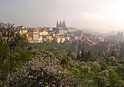
Foggy Sunday morning above Prague Castle and Malá Strana, as captured from Petřín. Praha, Czech Republic.
Ricoh GX100, interval 5 seconds, speed 150x
20090428_0620-0847utc_CeskyKrumlov-I.mpg
(46 MB, 1024x720, MPEG1)
20090428_0620-0847utc_CeskyKrumlov-I.mov
(48 MB, 1024x720, H.264 / QuickTime)
20090428_0620-0847utc_CeskyKrumlov-I.mp4
(39 MB, 1024x720, H.264 / MPEG-4)
Wave clouds (altocumulus) above Český Krumlov, south Bohemia, Czech Republic (view approx. towards northeast). Notice how the wave clouds disappear at the end of this sequence, with approach of high (cirrus) clouds from the east.
Ricoh GX100, interval 5 seconds, speed 150x
20090428_1420-1530utc_CeskyKrumlov-II.mpg
(22 MB, 1024x720, MPEG1)
20090428_1420-1530utc_CeskyKrumlov-II.mov
(20 MB, 1024x720, H.264 / QuickTime)
20090428_1420-1530utc_CeskyKrumlov-II.mp4
(39 MB, 1024x720, H.264 / MPEG-4)
Late afternoon shallow convection (cumulus clouds) and wave clouds (altocumulus) above Český Krumlov and Kleť (mountain in the center of the image), south Bohemia. The low cumulus clouds tend to form and drift to the west in rows, called "convective streets".
Ricoh GX100, interval 5 seconds, speed 150x
20090428_1635-1920utc_CeskyKrumlov-III.mpg
(43 MB, 1024x720, MPEG1)
20090428_1635-1920utc_CeskyKrumlov-III.mov
(58 MB, 1024x720, H.264 / QuickTime)
20090428_1635-1920utc_CeskyKrumlov-III.mp4
(43 MB, 1024x720, H.264 / MPEG-4)
Pre-frontal clouds approaching from the west, accompanied again by wave clouds at the end of the day above Český Krumlov, south Bohemia. Timelapse sequences like this one belong technically among the most difficult ones to capture and process - not only because of the overall darkening, but namely from the perspective of white balance of the images of the whole series...

Ricoh GX100, interval 5 seconds, speed 150x
20090521_0753-0935_Kiev.mpg (34 MB, 1024x704, MPEG1)
20090521_0753-0935_Kiev.mov (30 MB,
1024x704, H.264 / QuickTime)
20090521_0753-0935_Kiev.mp4 (28 MB,
1024x704, H.264 / MPEG-4)
The center of Kiev, Ukraine. From the meteorological perspective a non-interesting case, showing only shallow convective clouds and high cirrus clouds, each carried at different direction. Otherwise, this sequence nicely documents different speed of processes occurring in the atmosphere and speed of human activities :-)
Ricoh GX100, interval 0.8 seconds, speed 24x
20090611_1022-1029utc_Kacerov.mpg
(14 MB, 1024x736, MPEG1
20090611_1022-1029utc_Kacerov.mov
(12 MB, 1024x736, H.264 / QuickTime)
20090611_1022-1029utc_Kacerov.mp4
(13 MB, 1024x736, H.264 / MPEG-4)
Turbulent cloud base of storm, preceding a gust front and heavy showers, accompanied by small hail. Captured from Praha - Kačerov, Czech Republic, using a continuous mode. In contrary to the interval mode, in the continuous mode the camera is doing its best, recording as many pictures as possible - in this case at speed 1.25 frames per second. See also the radar loop (10:04-10:49 UTC, radar Brdy, CHMI), Meteosat loop (MSG1, 06:00-15:00 UTC), and the MODIS/Terra image at 250m resolution (band 1), captured by the satellite between 10:27-10:28 UTC (data source: NASA/LAADS archive). The red cross/dot in these indicate the location from which the Ricoh timelapse movie was taken (camera facing south). And one more photo, taken at 10:27 UTC by Kodak P880.
Ricoh GX100, interval 5 seconds, speed 150x
20090629_1325-1440utc_Libus.mpg
(25 MB, 1024x768, MPEG1
20090629_1325-1440utc_Libus.mov
(23 MB, 1024x768, H.264 / QuickTime)
20090629_1325-1440utc_Libus.mp4
(21 MB, 1024x768, H.264 / MPEG-4)
Cumulus congestus in a sheared environment, captured from CHMI observatory Praha - Libus, Czech Republic.
Ricoh GX100, interval 0.65 seconds, speed 20x
20090629_1831-1845utc_Praha-Kacerov.mpg
(32 MB,
1024x768, MPEG1
20090629_1831-1845utc_Praha-Kacerov.mov
(47 MB, 1024x768,
H.264 / QuickTime)
20090629_1831-1845utc_Praha-Kacerov.mp4
(27 MB,
1024x768, H.264 / MPEG-4)
Gust front preceding a storm outflow (probably a weaker downburst) above Praha. Captured from Praha, Kačerov, using the continuous mode of the camera, northward view. On the front side of the gust front (left side in this sequence) are several inflow features resembling funnel clouds, however the detailed movie below shows no rotation of these. On the rear side of the gust front, just ahead of the precipitation, seems to be a large horizontal vortex, most likely generated by the downburst.
Detail: 18:31 - 18:35 UTC (0h 04m 10s) HD 720
20090629_1831-1835utc_Praha-Kacerov_detail.mpg
(12 MB,
1280x720, MPEG1
20090629_1831-1835utc_Praha-Kacerov_detail.mov
(20 MB,
1280x720, H.264 / QuickTime)
20090629_1831-1835utc_Praha-Kacerov_detail.mp4
(10 MB,
1280x720, H.264 / MPEG-4)
Detailed view of the front side of the gust front (crop from the previous sequence), with several inflow features resembling funnel clouds.
Ricoh GX100, interval 5 seconds, speed 150x
20090702_0914-0948utc_Rozmberk.mpg
(13 MB, 1024x768, MPEG1
20090702_0914-0948utc_Rozmberk.mov
(18 MB, 1024x768, H.264 / QuickTime)
20090702_0914-0948utc_Rozmberk.mp4
(11 MB, 1024x768, H.264 / MPEG-4)
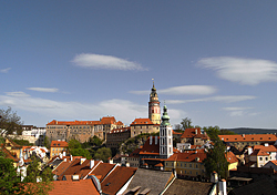
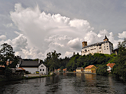
Cumulonimbus cloud above Rožmberk Castle and Vltava River, south Bohemia, Czech Republic.
Ricoh GX100, interval 5 seconds, speed 150x
20090704_0848-0938utc_Cesky-Krumlov.mpg
(17 MB, 1024x768, MPEG1
20090704_0848-0938utc_Cesky-Krumlov.mov
(22 MB, 1024x768, H.264 / QuickTime)
20090704_0848-0938utc_Cesky-Krumlov.mp4
(14 MB, 1024x768, H.264 / MPEG-4)
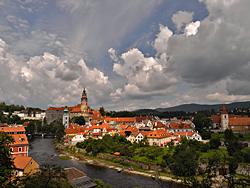
Shallow convective clouds above Český Krumlov, south Bohemia, Czech Republic.
Ricoh GX100, interval 5 seconds, speed 150x
20090714_2000-2110utc_NLC_Praha.mpg
(20 MB, 1280x720, MPEG1
20090714_2000-2110utc_NLC_Praha.mov
(100 MB, 1280x720, H.264 / QuickTime)
20090714_2000-2110utc_NLC_Praha.mp4
(20 MB, 1280x720, H.264 / MPEG-4)
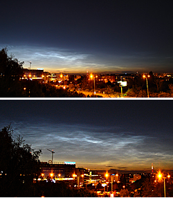
Noctilucent clouds (NLC) above Praha. Captured from Praha, Kačerov, Czech Republic, still image here. More details on NLC e.g. here or here.
Detail: 20:25 - 20:50 UTC (0h 25m) HD 720
20090714_2025-2050utc_NLC_Praha_detail.mpg
(10 MB, 1280x720, MPEG1
20090714_2025-2050utc_NLC_Praha_detail.mov
(28 MB, 1280x720, H.264 / QuickTime)
20090714_2025-2050utc_NLC_Praha_detail.mp4
(8 MB, 1280x720, H.264 / MPEG-4)
Detailed view (crop from the previous sequence), showing the fine structure of NLC.

Ricoh GX100, interval 0.6 seconds, speed 18x
20090715_0621-0625utc_Libus.mpg
(8 MB, 1024x624, MPEG1
20090715_0621-0625utc_Libus.mov
(12 MB, 1024x624, H.264 / QuickTime)
20090715_0621-0625utc_Libus.mp4
(10 MB, 1024x624, H.264 / MPEG-4)
Shelf cloud (or arcus) of an early morning storm, Praha, Libuš, Czech Republic. Camera facing south-west.
Ricoh GX100, interval 0.7 seconds, speed 42x
20090717_1804-1822utc_Kacerov.mpg (20 MB, 1040x720, MPEG1)
20090717_1804-1822utc_Kacerov.mov (31 MB,
1040x720, H.264 / QuickTime)
20090717_1804-1822utc_Kacerov.mp4 (18 MB, 1040x720, H.264 / MPEG-4)
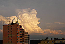
Convective cloud (Cumulus congestus) growing on the rear side of a thunderstorm under its anvil, illuminated by setting Sun. Captured in continuous mode, playback at 60 fps (frames per second). For cases like this one, an interval (timelapse) mode at about 2 seconds would be optimal (for playback at about 30 fps). Captured at Praha, Kačerov, Czech Republic.
Ricoh GX100, interval 2 seconds, speed 60x
20090720_1546-1620utc_2s_Kacerov.mpg
(28 MB, 1040x720, MPEG1)
20090720_1546-1620utc_2s_Kacerov.mov
(42 MB, 1040x720, H.264 / QuickTime)
20090720_1546-1620utc_2s_Kacerov.mp4
(23 MB, 1040x720, H.264 / MPEG-4)
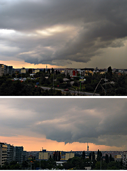
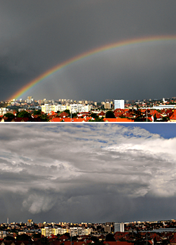
Another experiment with non-standard timelapse capture. While the two previous cases were captured in the continuous mode of the camera, in this case I just tried a 2 second interval (manual control with CA-1 remote release). Taken from Praha, Kačerov, Czech Republic.
Meteorologically this case is interesting by a feature, which developed on the back side of the shower (it moves into the frame from left side, approx. in middle of the sequence). Similar phenomena are often misinterpreted by public (namely on still photos) as a wall cloud, funnel cloud or even a tornado. However, in this case there is almost no rotation of the feature, and weak downward motion dominates for most of its life. On the quick-look (left) the feature is more prominent than on the original (or in reality) due to stronger image processing (unsharp mask).
Ricoh GX100, interval 5 seconds, speed 150x
20090726_1100-1510utc_CeskeStredohori.mpg
(33 MB, 1040x720, MPEG1)
20090726_1100-1510utc_CeskeStredohori.mov
(102 MB, 1040x720, H.264 / QuickTime)
20090726_1100-1510utc_CeskeStredohori.mp4
(28 MB, 1040x720, H.264 / MPEG-4)
Shallow convection above České Středohoří, western Bohemia, Czech Republic.
Ricoh GX100, interval 5 seconds, speed 150x
20090828_0850-1020utc_Libus.mpg
(29 MB, 1024x768, MPEG1)
20090828_0850-1020utc_Libus.mov
(35 MB, 1024x768, H.264 / QuickTime)
20090828_0850-1020utc_Libus.mp4
(25 MB, 1024x768, H.264 / MPEG-4)
Convective clouds, accompanied by weak showers, captured from my office window at Praha - Libuš. During this sequence, a second webcam was installed by Humlnet specialists at the top of the tower, in this case aimed at center of Prague (northward). All CHMI webcams can be found here, the first webcam at the tower aimed at the CHMI building (eastward) is here.
Ricoh GX100, interval 5 seconds, speed 150x
20090830_1304-1404utc_Lovos.mpg
(20 MB, 1024x768, MPEG1)
20090830_1304-1404utc_Lovos.mov
(26 MB, 1024x768, H.264 / QuickTime)
20090830_1304-1404utc_Lovos.mp4
(17 MB, 1024x768, H.264 / MPEG-4)
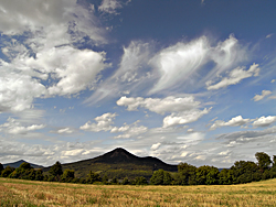
Show of shadows ... The highest (cirrus) clouds cast their shadows at mid-level (Altocumulus) and low-level (Cumulus) clouds, all together then at the ground. České Středohoří, western Bohemia, Czech Republic.
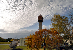
Ricoh GX100, interval 5 seconds, speed 150x
20090831_Libus_HRPT-MDA.mpg (61 MB, 1280x720, MPEG1)
20090831_Libus_HRPT-MDA.mov (51 MB, 1280x720, H.264
/ QuickTime)
20090831_Libus_HRPT-MDA.mp4 (50 MB,
1280x720, H.264 / MPEG-4)
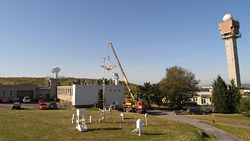
Old MDA HRPT antenna of CHMI being disassembled... This 4.5 m antenna was installed at Praha - Libuš in Dec.1978, served from Jan.1979 till mid-1995 for reception of HRPT data from the NOAA polar-orbiting weather satellites. In 1995 the old MDA HRPT system was replaced by a new one, from VCS, antenna of which can be seen in the left.
Ricoh GX100, interval 5 seconds, speed 150x
20090908_0450-0711utc_Rauris.mpg
(30 MB, 1280x720, MPEG1)
20090908_0450-0711utc_Rauris.mov
(49 MB, 1280x720, H.264 / QuickTime)
20090908_0450-0711utc_Rauris.mp4
(37 MB, 1280x720, H.264 / MPEG-4)
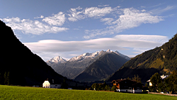
Wave clouds above the range of Hohe Tauern (Alps), captured from Rauris, Salzburgerland, Austria.
Ricoh GX100, interval 5 seconds, speed 125x
20090912_1226-1334utc_Krumltal.mpg
(27 MB, 1024x768, MPEG1)
20090912_1226-1334utc_Krumltal.mov
(34 MB, 1024x768, H.264 / QuickTime)
20090912_1226-1334utc_Krumltal.mp4
(23 MB, 1024x768, H.264 / MPEG-4)
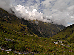
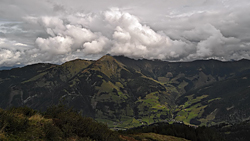
Shallow convective clouds, generated on the slopes above Krumltal Valley. Hohe Tauern National Park, Alps, Salzburgerland, Austria.
Ricoh GX100, interval 5 seconds, speed 150x
20090915_0511-0709utc_Rauris.mpg (27 MB, 1024x768, MPEG1)
20090915_0511-0709utc_Rauris.mov (38 MB,
1024x768, H.264 / QuickTime)
20090915_0511-0709utc_Rauris.mp4 (32 MB,
1024x768, H.264 / MPEG-4)
"Splashing" early morning fog in the valley, and low clouds dissipating on the northern, downwind side of the main range of the Hohe Tauern (Alps), above the Raurisertal (Rauris Valley). Captured from Rauris, Salzburgerland, Austria, southward view.
Ricoh GX100, interval 2 seconds, speed 60x
20090917_1145-1215utc_Grubereck.mpg
(20 MB, 1280x720, MPEG1)
20090917_1145-1215utc_Grubereck.mov (29 MB,
1280x720, H.264 /
QuickTime)
20090917_1145-1215utc_Grubereck.mp4 (21 MB,
1280x720, H.264 / MPEG-4)
One more case of convection induced locally by mountain range slopes. Taken at 2 second intervals, manual control of the camera by the CA-1 remote release. My strange activity made curious one filly, grazing nearby (1, 2, video). It was a bit difficult to maintain the regular 2-second intervals with this company :-)) Taken from slopes of Hirschkopf, facing Grubereck and Bernkogel (hills above Rauris, Austria).
Ricoh GX100, interval 5 seconds, speed 150x
20090918_0941-1042utc_Kitzsteinhorn.mpg
(20 MB, 1280x720, MPEG1)
20090918_0941-1042utc_Kitzsteinhorn.mov (34 MB,
1280x720, H.264 / QuickTime)
20090918_0941-1042utc_Kitzsteinhorn.mp4 (18 MB,
1280x720, H.264 / MPEG-4)
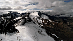
Clouds above the central part of Hohe Tauern National Park (Alps). View from Kitzsteinhorn towards Grossglockner (in clouds), with Hocheiser a Johannisberg in center of the image, and Weisssee in the right. Salzburgerland, Austria.
Ricoh GX100, interval 5 seconds, speed 150x
20090919_0454-0722utc_Edelweissspitze.mpg
(47 MB, 1280x720, MPEG1)
20090919_0454-0722utc_Edelweissspitze.mov (74 MB,
1280x720, H.264 / QuickTime)
20090919_0454-0722utc_Edelweissspitze.mp4 (39 MB,
1280x720, H.264 / MPEG-4)
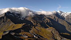
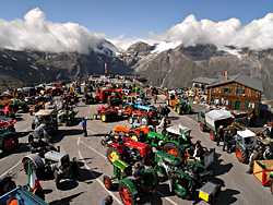
Morning clouds flowing across a mountain range near Grossglockner. The clouds, driven by southerly winds, form on the upwind southern side of the range, and dissolve on the downwind northern side of the range. Captured from top of the Edelweissspitze (2571 m), showing Fuscher Törl (1850 m), one of the summits of the Grossglockner High Alpine Road. In the second part of the movie notice the activity on the road (and the smoke above it :) - all the "dots", making their way up to the pass, are old tractors during their 8th Oldtimer Traktor WM uphill race. After reaching the final goal of the race at Fuscher Törl, some of the tractors continued even higher, to the parking lot at the top of Edelweissspitze - see the timelapse movie below. More photos of the old tractors from the race can be found e.g. here. Hohe Tauern National Park, Salzburgerland, Austria.
09:56 - 12:00 local time
(07:56 - 10:00 UTC, 2h 04m)
Ricoh GX100, interval 5 seconds,
speed 100x
20090919_OldtimerTraktorWM_Edelweissspitze.mpg
(60 MB, 1024x768, MPEG1)
20090919_OldtimerTraktorWM_Edelweissspitze.mov (66 MB,
1024x768, H.264 / QuickTime)
20090919_OldtimerTraktorWM_Edelweissspitze.mp4 (49 MB,
1024x768, H.264 / MPEG-4)
Ricoh GX100, interval 5 seconds, speed 150x
20091026_1040-1205utc_Libus.mpg (28 MB,
1040x720, MPEG1)
20091026_1040-1205utc_Libus.mov (93 MB,
1040x720, H.264 / QuickTime)
20091026_1040-1205utc_Libus.mp4 (24 MB,
1040x720, H.264 / MPEG-4)
Mid-level (altocumulus) and low-level convective clouds, and namely very nice vertical wind shear (change of wind direction and speed with height). Captured from my office window at Praha - Libuš, Czech Republic, south-west view.

Ricoh GX100, interval 5 seconds, speed 150x
20091115_0540-0640utc_Mandava.mpg
(15 MB, 1280x720, MPEG1)
20091115_0540-0640utc_Mandava.mov (24 MB,
1280x720, H.264 / QuickTime)
20091115_0540-0640utc_Mandava.mp4 (17 MB,
1280x720, H.264 / MPEG-4)
Cloud-wave before sunrise. Captured from Mandava, south of Prague, Czech Republic.
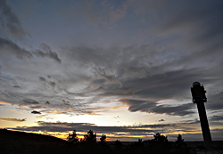
Ricoh GX100, interval 5 seconds, speed 150x
20091123_1412-1512utc_Libus.mpg (18 MB,
1040x720, MPEG1)
20091123_1412-1512utc_Libus.mov (35
MB, 1040x720, H.264 / QuickTime)
20091123_1412-1512utc_Libus.mp4 (34 MB,
1040x720, H.264 / MPEG-4)
Sunset and early evening sky from the Observatory Libuš, Prague, Czech Republic, south-west view.
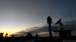
Ricoh GX100, interval 5 seconds, speed 150x
20091125_1447-1511utc_Libus-contrails.mpg
(6 MB, 1280x720, MPEG1)
20091125_1447-1511utc_Libus-contrails.mov (12 MB, 1280x720,
H.264 / QuickTime)
20091125_1447-1511utc_Libus-contrails.mp4
(12 MB, 1280x720, H.264 / MPEG-4)
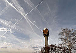
Contrails at Sunset. Nice example of different appearance of contrails depending on the humidity of their environment. While in the dry cloud-free air ahead of the pre-frontal cirrus clouds the contrails quickly evaporate, they are much better pronounced and more persistent in the moist air of the cirrus clouds area. Observatory Libuš, Prague, Czech Republic.
Ricoh GX100, interval 5 seconds, speed 150x
20091130_0930-1045utc_Libus-contrails.mpg
(25 MB, 1040x720, MPEG1)
20091130_0930-1045utc_Libus-contrails.mov
(33 MB, 1040x720, H.264 / QuickTime)
20091130_0930-1045utc_Libus-contrails.mp4
(32 MB, 1040x720, H.264 / MPEG-4)
Low-level wave clouds, cirrus and contrails. The reason why I initially started this sequence were the tiny waves of cumulus clouds, which can be also seen in this NOAA 17 image (at south-west part of the Czech Republic). Besides these, with the approach of pre-frontal cirrus clouds, very nice contrails began to form. Some of them, at higher flight levels even cast shadows at lower thin cirrus layers; the relative position of these shadows (with respect to the contrail itself) changes with drift of the contrail. Observatory Libuš, Prague, Czech Republic.

Ricoh GX100, interval 5 seconds, speed 150x
20091226_1347-1430utc_Ac-len_Polabi.mpg (19 MB,
1280x720, MPEG1)
20091226_1347-1430utc_Ac-len_Polabi.mov
(17 MB,
1280x720, H.264 / QuickTime)
20091226_1347-1430utc_Ac-len_Polabi.mp4
(20 MB,
1280x720, H.264 / MPEG-4)
Mid-level wave clouds above north-west part of Bohemia, captured from Praha, Kačerov, Czech Republic. See also the MSG satellite image, taken at the beginning of the Ricoh sequence (the red lines show the sector of view by Ricoh), and the MSG loop, showing the evolution of these waves from 11:00 till 15:00 UTC (the red dot indicating the timelapse period). Source of the MSG images: CHMI and EUMETSAT.