Ricoh GX100, interval 5 seconds, speed 150x
20100202_1100-1410utc_Libus.mpg (72 MB,
1280x720, MPEG1)
20100202_1100-1410utc_Libus.mov (94
MB, 1280x720, H.264 / QuickTime)
20100202_1100-1410utc_Libus.mp4 (74 MB,
1280x720, H.264 / MPEG-4)
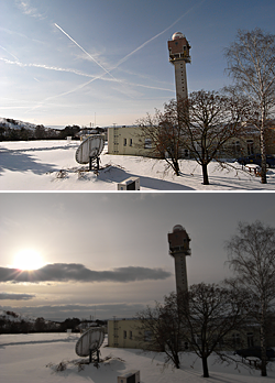
Contrails, low-level wave clouds, pre-frontal cirrus clouds.
Nice example of temporal and spatial variations of contrail formation, their appearance and persistence. At the later part of the timelapse movie, shallow convective clouds begin to form, partially being arranged in low-level waves. The timelapse movie ends shortly before the dense cirrus clouds cover entirely the area. Captured at Praha-Libus (from my office window), Czech Republic.
For additional comments on this case and corresponding satellite images see these notes.

Ricoh GX100, interval 5 seconds, speed 150x
20100227_1040-1140utc_Mandava.mpg (25 MB,
1040x720,
MPEG1)
20100227_1040-1140utc_Mandava.mov (30
MB, 1040x720, H.264 / QuickTime)
20100227_1040-1140utc_Mandava.mp4 (27 MB,
1040x720, H.264 / MPEG-4)
Shallow convective clouds above snow-covered land. At the beginning of the sequence, pileus clouds also form above some of the cumulus clouds. Taken at Mandava, central Bohemia, Czech Republic.
Ricoh GX100, interval 5 seconds, speed 150x
20100308_0836-0950utc_Libus.mpg
(31 MB, 1040x720,
MPEG1)
20100308_0836-0950utc_Libus.mov (46 MB, 1040x720,
H.264 / QuickTime)
20100308_0836-0950utc_Libus.mp4 (31 MB,
1040x720, H.264 / MPEG-4)
Winter is giving up, shallow convection indicates approaching spring. Captured at Praha-Libus, Czech Republic.

Ricoh GX100, interval 5 seconds, speed 150x
20100318_1540-1640utc_Alanya.mpg
(25 MB, 1280x720, MPEG1)
20100318_1540-1640utc_Alanya.mov
(30 MB, 1280x720, H.264 / QuickTime)
20100318_1540-1640utc_Alanya.mp4
(26 MB, 1280x720, H.264 / MPEG-4)
Sunset above the Gulf of Antalya. Captured from cliffs above Alanya, south Turkey.
Ricoh GX100, interval 5 seconds, speed 150x
20100319_1325-1410utc_Alanya-Ehmedek.mpg
(20 MB,
1280x720, MPEG1)
20100319_1325-1410utc_Alanya-Ehmedek.mov
(27 MB, 1280x720, H.264 / QuickTime)
20100319_1325-1410utc_Alanya-Ehmedek.mp4
(21 MB,
1280x720, H.264 / MPEG-4)
Tiny cumulus clouds above mountains of south coast of Turkey. Eastward view from Ehmedek, northern part of the Alanya Castle.

Ricoh GX100, interval 5 seconds, speed 150x
20100330_1326-1504utc_Kacerov.mpg (28 MB, 1040x720,
MPEG1)
20100330_1326-1504utc_Kacerov.mov (35 MB, 1040x720,
H.264 / QuickTime)
20100330_1326-1504utc_Kacerov.mp4 (32 MB, 1040x720,
H.264 / MPEG-4)
Mid-level wave clouds. Evolution of mid-level waves and altocumulus clouds, and their dissipation shortly ahead of pre-frontal cirrus clouds. Contrails and their shadows cast at altocumulus clouds. Captured from Praha - Kačerov (southward view), Czech Republic.
Ricoh GX100, interval 5 seconds, speed 150x
20100416_1648-1732utc_Radostovice.mpg
(19 MB, 1040x720,
MPEG1)
20100416_1648-1732utc_Radostovice.mov (25 MB, 1040x720,
H.264 / QuickTime)
20100416_1648-1732utc_Radostovice.mp4 (19 MB, 1040x720,
H.264 / MPEG-4)
Cloudy sunset under the volcanic ash from Iceland. The reddish sky is colored by clouds of volcanic ash, which was passing above the central Europe when this sequence was taken. Unfortunately, most of the sunset was hidden by regular clouds. Captured at Radostovice, district of Tábor, south Bohemia, Czech Republic. See also the loop of MSG1 satellite images (MOV file, 50 MB), showing the "24-hour microphysical RGB product" for 15-17 April 2010. The volcanic ash cloud is depicted here in bright orange (arrowed in this image from 18:00 UTC). Satellite data source: © 2010 CHMI and EUMETSAT.

Ricoh GX100, interval 5 seconds, speed 125x
20100418_0400-0600utc_Radostovice-Kacer.mpg (44 MB, 1280x720, MPEG1)
20100418_0400-0600utc_Radostovice-Kacer.mov (42 MB, 1280x720, H.264 /
QuickTime)
20100418_0400-0600utc_Radostovice-Kacer.mp4 (55 MB, 1280x720, H.264 / MPEG-4)
Foggy sunrise above a forest pond. Captured from a bank of half-empty pond "Kačer", Radostovice, south Bohemia, Czech Republic.
Ricoh GX100, interval 5 seconds, speed 150x
20100507_1516-1635utc_Milesovka.mpg
(29 MB, 1040x720,
MPEG1)
20100507_1516-1635utc_Milesovka.mov (32 MB, 1040x720,
H.264 / QuickTime)
20100507_1516-1635utc_Milesovka.mp4 (31 MB, 1040x720,
H.264 / MPEG-4)
Mixed cloudiness above Milešovka, České Středohoří. Clouds of various levels - from shallow convection, to mid-level altocumulus clouds and high level cirrus clouds. Vertical wind shear, wave clouds. Northwest Bohemia, Czech Republic.

Ricoh GX100, interval 0.8 seconds, speed 25x
20100815_1749-1815utc_Praha.mpg
(54 MB, 1280x720, MPEG1)
20100815_1749-1815utc_Praha.mov (55 MB, 1280x720, H.264 /
QuickTime)
20100815_1749-1815utc_Praha.mp4 (61 MB, 1280x720, H.264 / MPEG-4)
Sunset cumulonimbus north of Praha. This spectacular Cb has evolved shortly before sunset north of Prague. It was confused by many with the evening severe hailstorm, which occurred in south parts of Praha (causing large damage namely at parts of Praha 4, next case). Captured in continuous mode from Praha - Kačerov, northward view.
Ricoh GX100, interval 2/4 seconds, speed 20/40x
20100815_1848-1902utc_Praha-Krc.mpg
(21 MB, 1040x720, MPEG1)
20100815_1848-1902utc_Praha-Krc.mov
(30 MB, 1040x720,
H.264 / QuickTime)
20100815_1848-1902utc_Praha-Krc.mp4
(22 MB, 1040x720,
H.264 / MPEG-4)
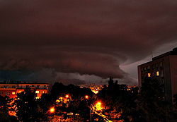
Evening hailstorm above Praha - Krč. This storm (probably a supercell) has caused severe hail damage at parts of Praha 4. Captured in continuous mode, approx. first 1/4 of the movie at 2-sec exposures, the rest at 4-sec exposures. The clouds are illuminated by city lights, which - after strong enhancement in Photoshop - gives the clouds the reddish appearance. Taken from Praha Kačerov, Czech Republic, southward view. See also the Czech radar network composite reflectivity loop (16:30 - 20:00 UTC, black cross showing the location from where the timelapse was captured), and Brdy radar reflectivity loop (120km range, PPI 0.6°, here the red dot marks the location and approximate time of the timelapse movie). Data source: CHMI.
Ricoh GX100, interval 0.6 seconds, speed 15x
20100827_112120-112250utc_Praha_0.6s.mpg
(7 MB,
1080x720, MPEG1)
20100827_112120-112250utc_Praha_0.6s.mov
(17 MB, 1080x720, H.264 / QuickTime)
20100827_112120-112250utc_Praha_0.6s.mp4
(6 MB,
1080x720, H.264 / MPEG-4)
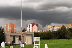
Funnel cloud (?) above Praha 4. Captured in continuous mode from the CHMI observatory at Praha Libuš, NE view. Slightly enhanced in Photoshop.

Ricoh GX100, interval 5 seconds, speed 150x
20100921_1217-1353utc_Cordoba.mpg
(40 MB, 1280x720,
MPEG1)
20100921_1217-1353utc_Cordoba.mov
(68 MB, 1280x720, H.264 / QuickTime)
20100921_1217-1353utc_Cordoba.mp4
(37 MB, 1280x720, H.264 / MPEG-4)
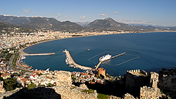
Shallow convection above Córdoba, Spain. Late September, midday cumulus clouds above historical center of Córdoba, and its Puente Romano bridge, origins of which date back to the 1st century. Captured from southern bank of the Guadalquivir River, NW view.

Ricoh GX100, interval 5 seconds, speed 150x
20101009_0450-0540utc_Mandava.mpg
(19 MB, 1280x720,
MPEG1)
20101009_0450-0540utc_Mandava.mov (28 MB,
1280x720, H.264 / QuickTime)
20101009_0450-0540utc_Mandava.mp4
(21 MB, 1280x720, H.264 / MPEG-4)
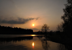
Cirrus and contrails at sunrise. A mixture of natural cirrus clouds, some of them forming waves, and condensation trails (contrails) at various stages of dissipation illuminated by rising Sun. Also a nice upper Sun pillar and faint parhelia ("sun dogs"). Captured at Mandava, central Bohemia, Czech Republic.
For additional comments on this case and related satellite imagery see these notes.

Ricoh GX100, interval 5 seconds, speed 150x
20101027_0715-0815utc_Libus-Kamyk.mpg
(25 MB, 1280x720,
MPEG1)
20101027_0715-0815utc_Libus-Kamyk.mov (33 MB, 1280x720, H.264
/
QuickTime)
20101027_0715-0815utc_Libus-Kamyk.mp4 (24 MB,
1280x720, H.264 / MPEG-4)
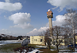
Brocken Spectre above Libuš. Glory (Brocken Spectre) around top part of the radar tower at Libuš, cast on a morning fog streaming north in the Vltava River valley. Praha, Czech Republic.