Time-lapse photography of clouds and other phenomena in the sky

Martin Setvak
 

18 May - 13 June 2010 trip to the U.S.A. (Colorado and Utah)

Back to the main page
Zpět na hlavní stránku


On this page you will find a collection of timelapse movies taken during my May - June 2010 trip to the U.S.A.  In the first part are several timelapse movies from our storm chase in northeast Colorado.  In the second part (scroll down) are all the other timelapse movies - some of them taken during the period of our visit of NOAA/NESDIS/RAMMB at CIRA, Fort Collins, and the rest are from our Colorado - Utah private trip.

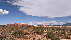
Storms of 26 May 2010, Colorado   As our main interest was timelapsing the storms, we stayed a bit further away from them, and did not attempt chasing their cores. Our group consisted of myself, Dan Lindsey (CIRA, Fort Collins) guiding us most of the day, and my CHMI colleague Jindrich Stastka. This radar loop (MOV, 8 MB) shows the evolution of all the storms in the area (the numbers appearing by the individual storms refer to the text below, roughly showing the time of the corresponding timelapse, and direction from which the storms were captured). Source of the radar data: NCDC, visualization: NOAA's Weather and Climate Toolkit.  See also the GOES-11 satellite loops, showing the evolution of these storms from the geostationary orbit - VIS (MOV, 12 MB), and the so-called sandwich product of visible and enhanced IR-window bands (MOV, 13 MB; details about the sandwich product can be found here). The blue outline in the sandwich product corresponds to 240 K cloud top temperature, dark red to 200 K.  For each of the individual cases below you will also find a still satellite image (closest to the nominal time of the timelapse), indicating by red dots the location from which the timelapse sequence was taken. The lower left dot indicates the real ground location, the upper right dot shows a relative, parallax-shifted cloud-top position (the parallax shift results from a tilted view of the satellite - the higher is the cloud top, the larger is the shift of the apparent cloud-top position).

2010 - 05 - 26   20:29 - 20:34 UTC  (0h 15m)  /  14:29 - 14:34 local time (MDT)     HD 720
Ricoh GX100,  interval 0.7 second,  speed 20x

20100526_2029-2044utc_BridleRidge.mpg  (29 MB, 1280x720, MPEG1)
20100526_2029-2044utc_BridleRidge.mov   (59 MB, 1280x720, H.264 / QuickTime)
20100526_2029-2044utc_BridleRidge.mp4  (40 MB, 1280x720, H.264 / MPEG-4)

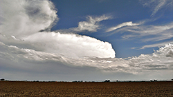
Our first storm timelapsed on that day. Captured from Bridle Ridge, east of Fort Collins, close to the intersection of state highway 14 and Co Rd 17, camera aimed towards Denver (to the south-southwest). See also the GOES-11 2041 UTC image, and this detailed radar loop (MOV, 6 MB) from the radar in Cheyenne, showing very nicely the formation and approach of the curved band of heavy precipitation (the red dot indicates our position). Taken in the continuous mode of the camera, giving about 0.7 second interval between the individual images. Approximately in the middle of the movie the camera was slightly shifted to the left (east). With onset of the rain we had to terminate the sequence and get back to our cars.

2010 - 05 - 26   21:15 - 21:45 UTC  (0h 30m)  /  15:15 - 15:45 local time (MDT)    HD 720
Ricoh GX100,  interval 5 seconds,  speed 125x

20100526_2115-2145utc_Colorado-storm2.mpg  (13 MB, 1280x720, MPEG1)
20100526_2115-2145utc_Colorado-storm2.mov   (20 MB, 1280x720, H.264 / QuickTime)
20100526_2115-2145utc_Colorado-storm2.mp4  (18 MB, 1280x720, H.264 / MPEG-4

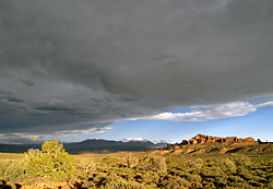
Second storm of the day, further south. Taken south of Eaton, from Co Rd 72, between state highway 85 and Co Rd 37, camera aimed S-SE; see also the GOES-11 2130 UTC image. This sequence was strongly enhanced in Photoshop, as the original images were too bright, not showing any anvil details (compare the original and processed images). The sequence was terminated by a gust, knocking down the tripods with our cameras; fortunately the cameras have survived without any noticeable harm.

2010 - 05 - 26   23:27 - 23:44 UTC  (0h 17m)  /  17:27 - 17:44 local time (MDT)     HD 720
Ricoh GX100,  interval 0.8 second,  speed 25x

20100526_2327-2344utc_Colorado-storm3.mpg  (30 MB, 1280x720, MPEG1)
20100526_2327-2344utc_Colorado-storm3.mov   (37 MB, 1280x720, H.264 / QuickTime)
20100526_2327-2344utc_Colorado-storm3.mp4  (36 MB, 1280x720, H.264 / MPEG-4)

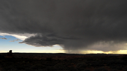
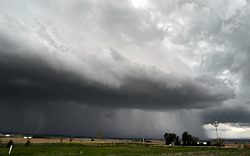
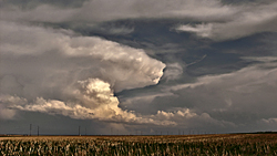
Inflow (updraft) region of our third storm. Captured in continuous mode south of Keenesburg, from Co Rd 59, between Prospect Reservoir and E 160 Ave, S-SE view; see also the GOES-11 2330 UTC image. Strongly enhanced in Photoshop (original, processed), however resembling very well the visual appearance of the storm. Very nice example of formation of back-sheared anvil (anvil spreading upwind, against the upper-level flow), resulting from strong updrafts. Shake of the movie results from strong low-level winds.

2010 - 05 - 27   00:29 - 00:42 UTC  (0h 13m)  /  2010-05-26  18:29 - 18:42 local time (MDT)      HD 720
Ricoh GX100,  interval 0.7 second,  speed 20x

20100527_0029-0042utc_Colorado-storm3.mpg  (21 MB, 1280x720, MPEG1)
20100527_0029-0042utc_Colorado-storm3.mov   (22 MB, 1280x720, H.264 / QuickTime)
20100527_0029-0042utc_Colorado-storm3.mp4  (35 MB, 1280x720, H.264 / MPEG-4)

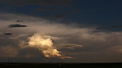
Updrafts of the same storm, taken somewhat later and further south, from Co Rd 59, between E 152 Ave and E 154 Ave, S-SE view; see also the GOES-11 0030 UTC image. Also captured in continuous mode, and strongly enhanced in Photoshop (original, processed). The low-level winds were even stronger here, I had to hold tight the tripod, sitting on the roof of our car.

2010 - 05 - 27   01:34 - 01:46 UTC  (0h 12m)  /  2010-05-26  19:34 - 19:46 local time (MDT)     HD 720
Ricoh GX100,  interval 0.8 second,  speed 25x

20100527_0134-0146utc_Denver.mpg  (26 MB, 1280x720, MPEG1)
20100527_0134-0146utc_Denver.mov   (30 MB, 1280x720, H.264 / QuickTime)
20100527_0134-0146utc_Denver.mp4  (29 MB, 1280x720, H.264 / MPEG-4)

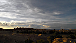
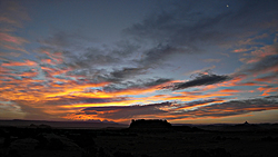
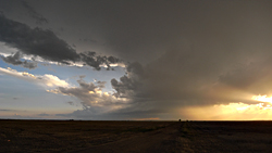
Storm close to Denver at sunset. Our fourth, final storm of the day, and probably the most beautiful one. Taken from intersection of Co Rd 69 and Co Rd 4, westward view (to northern parts of Denver), see also the GOES-11 0141 UTC image, in continuous mode. The sequence was terminated by rain. With sunset we headed back "home", to our hotel at Fort Collins.


Other timelapse movies from Colorado and Utah  
2010 - 05 - 30   01:04 - 02:23 UTC   (1h 19m)  /  2010-05-29  19:04 - 20:23 local time (MDT)     HD 720
Ricoh GX100,  interval 5 seconds,  speed 150x

20100530_0104-0223utc_RockyMountainNP.mpg  (32 MB, 1280x720, MPEG1)
20100530_0104-0223utc_RockyMountainNP.mov  (35 MB, 1280x720, H.264 / QuickTime)
20100530_0104-0223utc_RockyMountainNP.mp4  (34 MB, 1280x720, H.264 / MPEG-4)

Anvils of distant storms and wave clouds at sunset, captured from the Trail Ridge Road (west of Rock Cut point, approx. SE view) in Rocky Mountain National Park, Colorado. After the wind-related problems with tripods on our storm chase (above), I purchased a much better one, Manfrotto 7301YB, which I used for rest of the trip. The advantage of this tripod is that its legs can be set independently in two different angle positions, giving the tripod much better stability in strong winds, like here.

2010 - 05 - 30   21:08 - 22:01 UTC   (0h 53m)  /  15:08 - 16:01 local time (MDT)    HD 720
Ricoh GX100,  interval 5 seconds,  speed 150x

20100530_2108-2201utc_MountCumulus.mpg  (22 MB, 1280x720, MPEG1)
20100530_2108-2201utc_MountCumulus.mov   (34 MB, 1280x720, H.264 / QuickTime)
20100530_2108-2201utc_MountCumulus.mp4  (22 MB, 1280x720, H.264 / MPEG-4)

Cumulus clouds above Mount Cumulus    No, this is not a joke, several peaks of the Never Summer Mountains in the west part of Rocky Mountain NP really are named after clouds, see here.  For me, being a meteorologist, this simply was a MUST timelapse to take ... 

2010 - 06 - 05   01:30 - 02:37 UTC   (1h 07m)  /  2010-06-04  19:30 - 20:37 local time (MDT)    
Ricoh GX100,  interval 5 seconds,  speed 150x

20100605_0130-0237utc_DeadHorsePoint.mpg  (25 MB, 1040x720, MPEG1)
20100605_0130-0237utc_DeadHorsePoint.mov   (25 MB, 1040x720, H.264 / QuickTime)
20100605_0130-0237utc_DeadHorsePoint.mp4  (27 MB, 1040x720, H.264 / MPEG-4)

Canyons and meander of the Colorado River at sunset. Taken from the Dead Horse Point State Park, Utah. Nothing particularly interesting about the clouds in this case; I just liked the scenery and the game of light and shadows cast by the setting Sun.

2010 - 06 - 06   00:45 - 02:55 UTC   (2h 10m)  /  2010-06-05  18:45 - 20:55 local time (MDT)    HD 720
Ricoh GX100,  interval 5 seconds,  speed 150x

20100606_0045-0255utc_Arches1.mpg  (52 MB, 1280x720, MPEG1)
20100606_0045-0255utc_Arches1.mov   (48 MB, 1280x720, H.264 / QuickTime)
20100606_0045-0255utc_Arches1.mp4  (49 MB, 1280x720, H.264 / MPEG-4)

La Sal Mountains and the Windows rock formations at sunset.  Shallow cumulus clouds, cloud shadows, and at the end of the sequence (after sunset) a shadow of the horizon cast on the sky. Taken from the Panorama Point, Arches NP, Utah, east-southeast view.
2010 - 06 - 06   22:35 - 23:16 UTC   (0h 41m)  /  16:35 - 17:16 local time (MDT)     HD 720
Ricoh GX100,  interval 5 seconds,  speed 150x

20100606_2235-2316utc_Arches2.mpg  (19 MB, 1280x720, MPEG1)
20100606_2235-2316utc_Arches2.mov   (16 MB, 1280x720, H.264 / QuickTime)
20100606_2235-2316utc_Arches2.mp4  (18 MB, 1280x720, H.264 / MPEG-4)

Distant convection above the Windows, Arches NP, Utah. Taken from a small parking lot close to Rock Pinnacles, camera aimed at east-northeast direction. The high stratiform clouds, moving into the frame at the end of the sequence, already belong to the anvil of the storm shown below.

2010 - 06 - 07   00:46 - 01:05 UTC   (0h 19m)  /  2010-06-06  18:46 - 19:05 local time (MDT)     HD 720
Ricoh GX100,  interval 5 seconds,  speed 125x

20100607_0046-0105utc_Arches3.mpg  (9 MB, 1280x720, MPEG1)
20100607_0046-0105utc_Arches3.mov   (11 MB, 1280x720, H.264 / QuickTime)
20100607_0046-0105utc_Arches3.mp4  (11 MB, 1280x720, H.264 / MPEG-4)

Thunderstorm above Arches and Canyonlands NP, Utah.  Dry desert air causes most of the rain to evaporate before reaching the ground, thus the colder outflow from the storm is manifested at ground level namely by a blowing dust. Taken from a road shoulder close to the Garden of Eden, at the Windows section of Arches NP, westward view.

2010 - 06 - 07   01:48 - 02:48 UTC   (1h 00m)  /  2010-06-06  19:48 - 20:48 local time (MDT)    
Ricoh GX100,  interval 5 seconds,  speed 150x

20100607_0148-0248utc_Arches4.mpg  (24 MB, 1040x720, MPEG1)
20100607_0148-0248utc_Arches4.mov   (27 MB, 1040x720, H.264 / QuickTime)
20100607_0148-0248utc_Arches4.mp4  (24 MB, 1040x720, H.264 / MPEG-4)

Clouds and shadows above La Sal Mountains and Arches NP (Windows) at sunset. Anvil clouds of the storm from above, quickly evaporating shortly before the sunset, and shadows cast by clouds at horizon on the other (western) part of the sky. Taken from the Panorama Point, east-southeast view.

2010 - 06 - 08   01:10 - 03:15 UTC   (2h 05m)  /  2010-06-07  19:10 - 21:15 local time (MDT)     HD 720
Ricoh GX100,  interval 5 seconds,  speed 150x

20100608_0110-0315utc_Needles-sunset.mpg  (34 MB, 1280x720, MPEG1)
20100608_0110-0315utc_Needles-sunset.mov   (52 MB, 1280x720, H.264 / QuickTime)
20100608_0110-0315utc_Needles-sunset.mp4  (45 MB, 1280x720, H.264 / MPEG-4)

Clouds above Canyonlands at sunset. A mixture of high cirrus clouds, distant cumulonimbus, and low cumulus clouds at sunset. Taken from the Squaw Flat campground at Needles, Canyonlands NP, Utah, northward view.

2010 - 06 - 08   11:36 - 12:26 UTC   (0h 50m)  /  2010-06-08  05:36 - 06:26 local time (MDT)     HD 720
Ricoh GX100,  interval 5 seconds,  speed 125x

20100608_1136-1226utc_Needles-sunrise.mpg  (16 MB, 1280x720, MPEG1)
20100608_1136-1226utc_Needles-sunrise.mov   (43 MB, 1280x720, H.264 / QuickTime)
20100608_1136-1226utc_Needles-sunrise.mp4  (25 MB, 1280x720, H.264 / MPEG-4)

Spectacular morning sky above Canyonlands and La Sal Mountains. Mostly wave clouds, illuminated by the rising Sun. Captured from rocks above the Squaw Flat campground at Needles, Canyonlands NP, Utah, northeast view.

2010 - 06 - 09   19:55 - 21:30 UTC   (1h 35m)  /  2010-06-09  13:55 - 15:30 local time (MDT)     HD 720
Ricoh GX100,  interval 5 seconds,  speed 150x

20100609_1955-2130utc_BlueMesa.mpg  (31 MB, 1280x720, MPEG1)
20100609_1955-2130utc_BlueMesa.mov   (78 MB, 1280x720, H.264 / QuickTime)
20100609_1955-2130utc_BlueMesa.mp4  (36 MB, 1280x720, H.264 / MPEG-4)

Convective clouds above the Blue Mesa. Early afternoon convection, captured from the Blue Mesa Reservoir, Colorado, E-SE view.


2010 - 06 - 11   01:26 - 02:30 UTC   (1h 04m)  /  2010-06-10  19:26 - 20:30 local time (MDT)     HD 720
Ricoh GX100,  interval 5 seconds,  speed 150x

20100611_0126-0230utc_SangreDeCristo.mpg  (27 MB, 1280x720, MPEG1)
20100611_0126-0230utc_SangreDeCristo.mov   (45 MB, 1280x720, H.264 / QuickTime)
20100611_0126-0230utc_SangreDeCristo.mp4  (25 MB, 1280x720, H.264 / MPEG-4)

Wave-clouds above Sangre De Cristo Range at sunset. Captured from San Luis Campground (south of Villa Grove), Colorado, eastward view. Besides the wave clouds, most of the other clouds drifting into the view from the west (from "overhead") are remains of dissipating thunderstorm anvils, some of them forming weak mamma clouds.

Regrettably, this was the last timelapse of our Colorado-Utah trip ...    

Back to the main page
Zpět na hlavní stránku