Ricoh GX100, interval 5 seconds, speed 150x
20110104_0631-0743utc_eclipse-Praha.mpg (27 MB,
1040x720, MPEG1)
20110104_0631-0743utc_eclipse-Praha.mov (30
MB,
1040x720, H.264 / QuickTime)
20110104_0631-0743utc_eclipse-Praha.mp4 (28 MB,
1040x720, H.264 / MPEG-4)
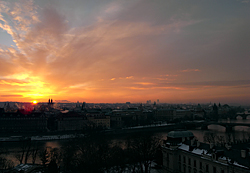
Eclipse Sunrise above Prague. Partially eclipsed Sun, almost symbolically rising above the Týn Church, in which is the tomb of famous Danish astronomer Tycho Brahe. Details of the eclipse can't be resolved in this movie, as the Sun itself is too much overexposed here. See also a zoomed photo of the partially eclipsed Sun above the Týn Church, taken with Kodak P880 camera. Captured from Letná, Praha, Czech Republic.

Ricoh GX100, interval 2 seconds, speed 60x
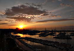
20110205_0630-0715utc_Karluv-most.mpg
(45 MB, 1280x720,
MPEG1)
20110205_0630-0715utc_Karluv-most.mp4
(42 MB, 1280x720,
H.264 / MPEG-4)
Ricoh GX100, interval 5 seconds, speed 150x
20110319_1620-1800utc_Petrin.mpg (38 MB, 1280x720, MPEG1)
20110319_1620-1800utc_Petrin.mp4 (37 MB, 1280x720, H.264 / MPEG-4)
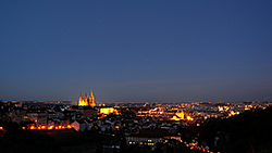
End of a day above Prague. Captured from Petřín hill, from a viewpoint close to the Strahov Monastery.
Ricoh GX100, interval 5 seconds, speed 150x
20110401_1340-1440utc_Kacerov.mpg (23 MB, 1040x720, MPEG1)
20110401_1340-1440utc_Kacerov.mov (24 MB, 1040x720, H.264 / QuickTime)
20110401_1340-1440utc_Kacerov.mp4 (23 MB, 1040x720, H.264 / MPEG-4)
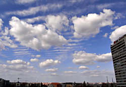
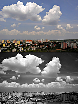
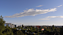
Waves in cirrus clouds above Prague. Captured from Kačerov, Prague, Czech Republic, northward view.
Ricoh GX100, interval 5 seconds, speed 150x
20110409_1250-1350utc_Praha-IR.mpg (24 MB, 1040x720, MPEG1)
20110409_1250-1350utc_Praha-IR.mp4 (22 MB, 1040x720, H.264 / MPEG-4)
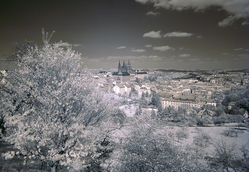
2011 - 04 - 09 13:40 - 14:10 UTC (0h 30m) HD 720
Ricoh GX100, interval 2 seconds, speed 60x
20110409_1340-1410utc.mpg (32 MB, 1280x720, MPEG1)
20110409_1340-1410utc.mp4 (29 MB, 1280x720, H.264 / MPEG-4)
Ricoh GX100, interval 5 seconds, speed 150x
20110430_1155-1255utc_Libus_VIS.mpg (24 MB, 1080x720, MPEG1)
20110430_1155-1255utc_Libus_VIS.mov (29 MB, 1080x720, H.264 / QuickTime)
20110430_1155-1255utc_Libus_VIS.mp4 (25 MB, 1080x720, H.264 / MPEG-4)
20110430_1155-1255utc_Libus_IR72.mpg (25 MB, 1080x720, MPEG1)
20110430_1155-1255utc_Libus_IR72.mov (26 MB, 1080x720, H.264 / QuickTime)
20110430_1155-1255utc_Libus_IR72.mp4 (25 MB, 1080x720, H.264 / MPEG-4)
Ricoh GX100, interval 2.5 seconds, speed 75x
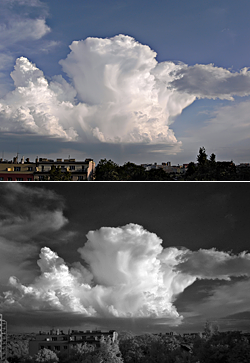
20110519_1615-1730utc_VIS_2.5s_Kacerov-Cb.mpg (53 MB, 1040x752, MPEG1)
20110519_1615-1730utc_VIS_2.5s_Kacerov-Cb.mov (55 MB, 1040x752, H.264 / QuickTime)
20110519_1615-1730utc_VIS_2.5s_Kacerov-Cb.mp4 (56 MB, 1040x752, H.264 / MPEG-4)
and 15:55 - 17:30 UTC (1h 35m)
Ricoh GX100, interval 5 seconds, speed 150x
20110519_1555-1730utc_IR72_5s_Kacerov-Cb.mpg (39 MB, 1040x752, MPEG1)
20110519_1555-1730utc_IR72_5s_Kacerov-Cb.mov (31 MB, 1040x752, H.264 / QuickTime)
20110519_1555-1730utc_IR72_5s_Kacerov-Cb.mp4 (36 MB, 1040x752, H.264 / MPEG-4)
See also the evolution of this storm as captured by Meteosat-8 (MSG-1) satellite at 5-minute steps (Rapid Scan Service), shown in the so-called "sandwich" RGB product (combining HRV and IR10.8 bands, product info here). Red dot in the loop indicates the location and time range of the two timelapse series above.
Ricoh GX100, interval 2.5 seconds, speed 75x
20110520_1638-1720utc_Kacerov_outflow-Cb.mpg (35 MB, 1040x752, MPEG1)
20110520_1638-1720utc_Kacerov_outflow-Cb.mov (31 MB, 1040x752, H.264 / QuickTime)
20110520_1638-1720utc_Kacerov_outflow-Cb.mp4 (33 MB, 1040x752, H.264 / MPEG-4)
Ricoh GX100, interval 5 seconds, speed 150x
20110619_0520-0730utc_Kacerov.mpg (52 MB, 1280x720, MPEG1)
20110619_0520-0730utc_Kacerov.mp4 (49 MB, 1280x720, H.264 / MPEG-4)
Ricoh GX100, interval 2 seconds, speed 40x
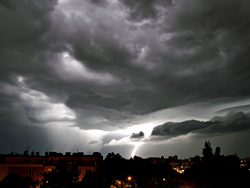
20110709_2215-2319utc_lightning-Praha4-Krc.mpg (64 MB, 1080x720, MPEG1)
20110709_2215-2319utc_lightning-Praha4-Krc.mp4 (60 MB, 1080x720, H.264 / MPEG-4)
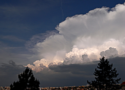
The radar loop from 22:00-23:40 UTC (with the cross indicating time and location of the timelapse sequence) shows a rather chaotic structure of this MCS, while the MSG1 satellite loop from 18:00-09:00 UTC shows the large horizontal extent of its cloud-top shield. MSG and radar imagery: © 2011 CHMI and EUMETSAT.
Ricoh GX100, interval 2 seconds, speed 40x
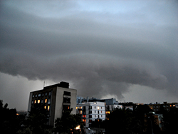
20110713_1854-1857utc_MCS-CZ_Kacerov.mpg (5 MB, 960x720, MPEG1)
20110713_1854-1857utc_MCS-CZ_Kacerov.mp4 (5 MB, 960x720, H.264 / MPEG-4)
See also the corresponding radar images from 18:55 and 19:00 UTC (CZRAD PPI 0.9°, small cross indicating the location from which the timelapse sequence has been captured), radar loop for 16:00-21:00 UTC showing the evolution and passage of this MCS and namely its bow-echos above the Czech Republic, and a short radar loop from 18:40-19:15 UTC with the cross indicating time and location of the timelapse sequence. The appearance of this MCS "from above" can be seen in the MSG1 18:35 UTC satellite image (sandwich HRV & IR10.8-BT product, description here), and its evolution in the 14:00-19:00 UTC MSG1 loop (the same image product, MOV, 13MB). MSG and radar imagery: © 2011 CHMI and EUMETSAT.
Ricoh GX100, interval 2.5 seconds, speed 75x
20110819_0737-0755utc_Libus.mpg (14 MB, 1040x720, MPEG1)
20110819_0737-0755utc_Libus.mov (15 MB, 1040x720, H.264 / QuickTime)
20110819_0737-0755utc_Libus.mp4 (16 MB, 1040x720, H.264 / MPEG-4)
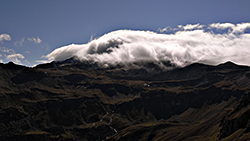
Ricoh GX100, interval 1.5 seconds, speed 45x
20110906_0855-0925utc_Hochtor-Plattenkar.mpg (37 MB, 1280x720, MPEG1)
20110906_0855-0925utc_Hochtor-Plattenkar.mp4 (38 MB, 1280x720, H.264 / MPEG-4)
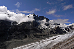
Ricoh GX100, interval 5 seconds, speed 150x
20110906_1100-1143utc_Grossglockner.mpg (19 MB, 1080x720, MPEG1)
20110906_1100-1143utc_Grossglockner.mp4 (18 MB, 1080x720, H.264 / MPEG-4)
Grossglockner, the highest mountain of Austria, and Pasterze Gracier, Hohe Tauern National Park.
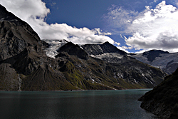
Ricoh GX100, interval 1.5 seconds, speed 45x
20110909_1309-1337utc_Kaprun-Mooserboden.mpg (38 MB, 1080x720, MPEG1)
20110909_1309-1337utc_Kaprun-Mooserboden.mp4 (36 MB, 1080x720, H.264 / MPEG-4)
Clouds and shadows I. Mooserboden Dam Lake (Kaprun), Hohe Tauern National Park, Alps, Austria.
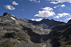
Ricoh GX100, interval 2.5 seconds, speed 75x
20110910_1218-1252utc_Oedenwinkelkees.mpg (29 MB, 1080x720, MPEG1)
20110910_1218-1252utc_Oedenwinkelkees.mp4 (27 MB, 1080x720, H.264 / MPEG-4)
Clouds and shadows II. The Ödenwinkelkees Glacier from Rudolfshütte, Weissee, Hohe Tauern National Park, Alps, Austria.
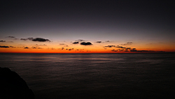
Ricoh GX100, interval 5 seconds, speed 150x
20111007_0510-0615utc_Palma-de-Mallorca.mpg (28 MB, 1040x720, MPEG1)
20111007_0510-0615utc_Palma-de-Mallorca.mp4 (26 MB, 1040x720, H.264 / MPEG-4)

Ricoh GX100, interval 5 seconds, speed 150x
20111009_0517-0613utc_Mallorca_Cala-dOr_KH-waves.mpg (25 MB, 1280x720, MPEG1)
20111009_0517-0613utc_Mallorca_Cala-dOr_KH-waves.mp4 (26 MB, 1280x720, H.264 / MPEG-4)
Ricoh GX100, interval 5 seconds, speed 150x
20111013_0510-0558utc_Mallorca_Cala-dOr.mpg (23 MB, 1280x720, MPEG1)
20111013_0510-0558utc_Mallorca_Cala-dOr.mp4 (23 MB, 1280x720, H.264 / MPEG-4)
Shallow convection at sunrise. Cala d'Or, Mallorca, Balearic Islands, Spain.
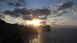
Ricoh GX100, interval 2 seconds, speed 60x
20111014_1624-1640utc_Cap-de-Formentor.mpg (20 MB, 1280x720, MPEG1)
20111014_1624-1640utc_Cap-de-Formentor.mp4 (20 MB, 1280x720, H.264 / MPEG-4)
Sunset at Cap de Formnetor. Mallorca, Balearic Islands, Spain.