Samsung NX 500 & Samyang 8mm F2.8 UMC Fisheye II, interval 7 seconds, speed 210x
20220107_0625-1150utc_Kacerov_x264_1920x1080.mp4 (134 MB)
20220107_0625-1150utc_Kacerov_x265_1920x1080.mkv (136 MB, H.265)
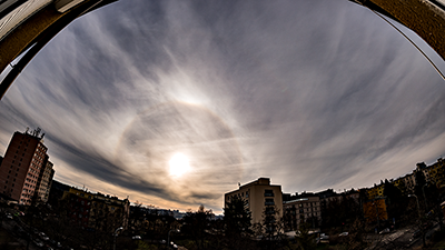
Cirrus morning. Cirrus clouds and waves in these, various halo phenomena, contrails (condensation trails) and their shadows. Visibility of several types of halo phenomena changes here significantly with varying microphysical composition of cirrus clouds passing above. As regards contrails and their shadows, only those contrails which are higher than the regular cirrus clouds cast shadows on these. Moreover, location of the contrail shadows with respect to the contrails themselves depends on their relative position to the Sun. The timelapse was captured from Praha - Kačerov, Czech Republic.
------------------------------------
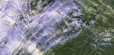
I was also curious to see how well these contrails can be seen in satellite imagery, namely in the M09 band (1.38 µm) of the VIIRS instrument bands, flown on NPP and NOAA-20 satellites. The 1.38 µm band will be one of the new bands of Flexible combined Imager (FCI) on Meteosat Third Generation (MTG) satellites, first of which (MTG-I1) is to be launched by the end of this year (Dec 2022). To learn what we can expect from FCI data, other recent satellites and their instruments, which already have some of the upcoming MTG FCI new bands, are used - including VIIRS. Also, the RGB Cloud Type image product (below) utilizes the 1.38 µm band. Some examples of utilization of the 1.38 µm band can be found here or here.
eumetrain.org/user-manual
------------------------------------
I was also curious to see how well these contrails can be seen in satellite imagery, namely in the M09 band (1.38 µm) of the VIIRS instrument bands, flown on NPP and NOAA-20 satellites. The 1.38 µm band will be one of the new bands of Flexible combined Imager (FCI) on Meteosat Third Generation (MTG) satellites, first of which (MTG-I1) is to be launched by the end of this year (Dec 2022). To learn what we can expect from FCI data, other recent satellites and their instruments, which already have some of the upcoming MTG FCI new bands, are used - including VIIRS. Also, the RGB Cloud Type image product (below) utilizes the 1.38 µm band. Some examples of utilization of the 1.38 µm band can be found here or here.
- NPP VIIRS images and products, 11:50 UTC (time of the end of the timelapse): I-bands (375m) RGB125, I5 band, BTD I5-I4, M-bands (750m) M09 (1.38 µm), RGB Cloud Type, RGB 24M. Contrails can be seen very well here, in most of these images, probably best in the RGB 24M. Though, in this case (detection of contrails above or within natural cirrus layers) the 1.38 µm band does not provide any new information, and the same is true for the RGB Cloud Type image product.
- MSG SEVIRI loops: RGB VIS-IR, RGB 24M and WV6.2 show extent and motion of the cirrus clouds, but none of these is capable of distinguishing the contrails in this case.
eumetrain.org/user-manual
Samsung NX 500 & Samyang 8mm F2.8 UMC Fisheye II, interval 4 seconds, speed 120x
20220620_0635-0720utc_roll-cloud_Kacerov_x264_1920x1080.mp4 (54 MB)
20220620_0635-0720utc_roll-cloud_Kacerov_x265_1920x1080.mkv (57 MB, H.265)
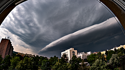
Roll cloud above southern parts of Praha, Czech Republic. See also static images from 07:08 UTC, 07:12 UTC and 07:14 UTC. Captured from Praha - Kačerov, view ranging from SE-S-W to NW. For definition of roll cloud see e.g. AMS Glossary of Meteorology.
While from a satellite perspective (MSG3 RSS HRV, 07:15 UTC) the roll cloud remained hidden under anvil of the storm, it was possible to reveal the roll cloud in data from ALC profiler located at Praha - Libu (roll cloud is indicated by arrow and two horizontal lines) and Praha - Karlov (source: e-profile.eu). According to these observations, height of this roll cloud was about 1.5 km a.s.l.
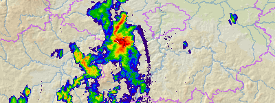
The roll cloud was also well discernible in CHMI radar Brdy PPI measurements at 0.5° - see this static PPI 0.5° image from 07:10 UTC and loop of PPI 0.5°images from 06:00 - 08:00 UTC and PPI at 0.9° - e.g. this 07:00 UTC image. The roll cloud is also nicely visible in vertical PPI cross-section from 07:00 UTC (along the line Plzeň-Nymburk) and in a loop of vertical cross-sections from 06:20 - 07:30 UTC. The roll cloud appears as tilted here due to scan strategy of the radar (from higher to lower PPIs) and its rapid eastward motion. Radar data source and visualization: CHMI Radar Dept., Dr. Petr Novák.
The roll cloud was also well discernible in CHMI radar Brdy PPI measurements at 0.5° - see this static PPI 0.5° image from 07:10 UTC and loop of PPI 0.5°images from 06:00 - 08:00 UTC and PPI at 0.9° - e.g. this 07:00 UTC image. The roll cloud is also nicely visible in vertical PPI cross-section from 07:00 UTC (along the line Plzeň-Nymburk) and in a loop of vertical cross-sections from 06:20 - 07:30 UTC. The roll cloud appears as tilted here due to scan strategy of the radar (from higher to lower PPIs) and its rapid eastward motion. Radar data source and visualization: CHMI Radar Dept., Dr. Petr Novák.
Samsung NX 500 & Samyang 12mm F2.0 NCS CS, interval 5 seconds, speed 150x
20220915_1038-1132utc_Lubina_1920x1080_x264.mp4 (44 Mb)
20220915_1038-1132utc_Lubina_1920x1080_x265.mkv (47 MB, H.265)
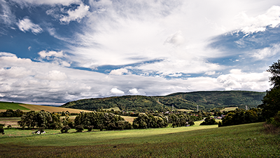
Pleivec and Saláky Hills from Lubina. Remake of my very first timelapse, which I took about 19 years ago. These hills are the northernmost end of Small Carpathians mountain range, located at southwest Slovakia; see also this photo. Family of my father comes from Bzince pod Javorinou, a village situated at base of Pleivec (lower of the two hills), where I spent almost every summer during my childhood. Lubina is a nearby village, where lives family of my father's sister. District of Nové Mesto nad Váhom, western Slovakia.
Samsung NX 500 & Samyang 12mm F2.0 NCS CS, interval 5 seconds, speed 150x
20220916_0620-0920utc_Cachtice_1920x1080_x264.mp4 (156 MB)
20220916_0620-0920utc_Cachtice_1920x1080_x265.mkv (188 MB, H.265)
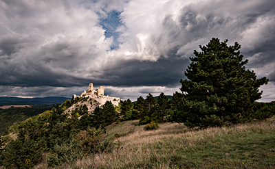
Čachtice Castle and gradual increase of pre-frontal clouds. Čachtice Castle is known namely because of its link to Hungarian countess Elizabeth Báthory, who was accused of torturing and killing as many as 600 young women within the walls of this castle. For me, it has always been a place I know since childhood, which I enjoy visiting anytime I'm in the region. See also this single photo from the timelapse, or my older timelapse of the castle, which I captured in 2008.
Samsung NX 500 & Samyang 8mm F2.8 UMC Fisheye II, interval 5 seconds, speed 150x
20221027_0500-0810utc_Hradcany_Mala-Strana_Petrin_1920x1080_x264.mp4 (160 MB)
20221027_0500-0810utc_Hradcany_Mala-Strana_Petrin_1920x1080_x265.mkv (160 MB, H.265)
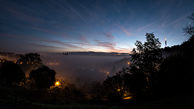
Morning fog above Praha (Hradčany, Malá Strana, Petřín). Captured from a viewpoint near Strahov Monastery, Praha, Czech Republic.
Gradual dissipation of fog above valleys of Vltava and Berounka rivers can be nicely seen in this loop of Meteosat-10 (MSG3) images in HRV band, taken in satellite's 5-minute Rapid Scan mode between 05:30 and 09:55 UTC.
See also a static image from polar-orbiting satellite NOAA-19, acquired at about 07:58 UTC, when the fog above Vltava River in Prague already dissipated, in the AVHRR band 1 and in RGB composite image (bands 1, 2 and 4).
See also a static image from polar-orbiting satellite NOAA-19, acquired at about 07:58 UTC, when the fog above Vltava River in Prague already dissipated, in the AVHRR band 1 and in RGB composite image (bands 1, 2 and 4).
Meteosat-11 (MSG4) SEVIRI, interval 15 minutes, speed 43 000x, video duration: 12m 35s
Earth-2022_1200x1080_x264.mp4 (496 MB)
Earth-2022_1200x1080_x265.mkv (497 MB, H.265, RGB24) - somewhat better quality than x264 version
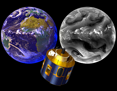
Earth in 2022 from Meteosat-11 satellite in water vapor absorption band. When I started timelapsing about 20 years ago, one of my motivations or inspirations were animations of satellite images from the then new Meteosat Second Generation (MSG) satellites. Strongly simplified, these are nothing else than giant, very complex digital cameras with a half-meter diameter lens, taking an image of the entire Earth every 15 minutes - which is the reason why we can consider satellite animations as a special form of timelapse movies.
The main instrument of MSG satellites, SEVIRI, scans the Earth in twelve different spectral channels (at different wavelengths, ranging from about 0.5 to 14 µm). One of these channels is the band centered at 6.2 µm, where significant absorption of thermal radiation emitted by the Earth's surface and lower clouds occurs. This means that the satellite sees only the highest clouds - mainly cirrus and cumulonimbus - and the distribution of water vapor in the upper third or so of the troposphere (at mid-latitudes, roughly the levels of the atmosphere between 7 and 12 km above the Earth's surface). This mosaic of images of the Earth shows a near-real-color view (VIS-IR, a combination of two visible and one thermal channels) on the left, and a WV6.2 (6.2 µm) channel image on the right. While in the VIS-IR image we see the distribution of all clouds and cloud-free land and sea/ocean surfaces roughly as the human eye would see everything, in the WV6.2 image we see only the highest clouds (white) and distribution of water vapor in the upper troposphere - the more water vapor in the atmosphere, the lighter is the shade of grey. So the main advantage of images in this channel is that we can see structure of the atmosphere and its flow even in cloud-free areas. It is this feature that makes it fascinating to observe the Earth's atmosphere in this channel - from storm clouds and cirrus in the tropics, driven by the trade winds to the west (in the so-called intertropical convergence zone), followed by meandering subtropical bands of jet streams flowing eastward, to the highly turbulent flow of cyclones and anticyclones at higher latitudes. For ease of orientation, I included a few days in the VIS-IR product at the beginning of the video, followed by the rest of the year in the channel WV6.2.
This timelapse is my tribute to MSG satellites, providing their data to meteorologists for about two decades by now, and to EUMETSAT personnel operating these satellites. I don't know how many of you will be able to keep watching this timelapse till its very end, but for meteorologist's eye it's difficult to break away from it, especially on larger monitors or TV screens. I hope you will enjoy it. And feel free to use it for any (non-commercial) educational and training activities.
Source of Meteosat-11 (MSG4) SEVIRI L1.5 HRIT data: EUMETSAT, processed operational images: CHMI archive,
subsequent minor enhancement in Adobe Photoshop, final video: VirtualDub2.
Music: The Sound of Lex - Between Worlds (album Deep Emotions, 2019)
thesoundoflex.wordpress.com/, www.facebook.com/thesoundoflex