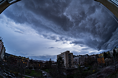
Sony A7C & TTArtisan 11mm F2.8 ED Fisheye, interval 4 seconds, speed 100x
20230330_1730-1755utc_Kacerov_25-fps_1920x1080_x264.mp4 (41 MB)
Evening shelf cloud. Captured from our flat at Praha - Kačerov, Czech Republic, southwestward view. See also these two static images - resized original (out of camera JPG) image, and image processed from raw file (uncompressed ARW file).
See also the CZRAD radar loop (red dot indicating place and time of the timelapse above) and MSG satellite loop (ending with sunset, just before the timelapse was started).
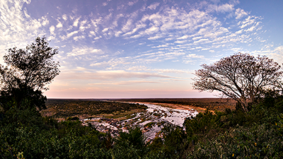
Sony A7C & TTArtisan 11mm F2.8 ED Fisheye, interval 5 seconds, speed 150x
20230505_0401-0518utc_Kruger_Olifants-River_1920x1080_x264.mp4 (70 MB)
Morning sky above Olifants River in Kruger National Park (or alternate site), from Olifants Rest Camp, South Africa (southward view). In Kruger Park (including fenced camps) you must not leave your tripod with camera unattended, otherwise Vervet monkeys or Baboons (present in most of places) may try to steal it, or at least damage it...
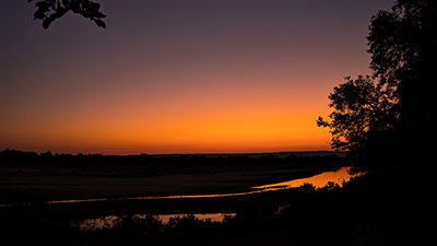
Sony A7C & Sony SEL2860, interval 5 seconds, speed 150x
20230507_0354-0507utc_Kruger_Letaba-River_1920x1080_x264.mp4 (50 MB)
Sunrise above Letaba River in Kruger National Park (or alternate site), from Letaba Rest Camp, South Africa. As we are south of the Equator, the Sun rises at opposite angle than at the northern hemisphere. And the "drifting boulders" in the river (at the beginning of the sequence) are hippos.

Sony A7C & TTArtisan 11mm F2.8 ED Fisheye, interval 25 seconds, speed 750x
20230510_1634-1937utc_Kruger_Punda-Maria_1620x1080.mp4 (37 MB)
Timelapse of the southern sky taken from Punda Maria Rest Camp in Kruger National Park (or alternate site), South Africa. As you can see from the timelapse, the night was rather bad, with some smoke spreading from the southwest (well seen in the lower right part of the movie) - see e.g. this fire product derived from MODIS and VIIRS data (source here). Unfortunately, it was the only nighttime timelapse I managed to take during our entire 10-day trip to the park. In the Kruger NP, it is forbidden to stay overnight outside the camps (for security reasons - wild animals), and all the camps have lighting - which makes night-time astrophotography almost impossible there. Also, we were in the park around the time of the full moon, so we only had dark skies on several last nights, for a couple of hours in the evening. The timelapse was taken from an upper terrace of our cottage there (the only place with an almost open view to the sky), which also was the source of the variable illumination of the nearby trees. Well, if you visit the Kruger NP, you are there for the animals, not for the night sky... Moreover, the surroundings of the Kruger NP are quite light-polluted, as can be seen in the right (western) part of the timelapse.
See also this still image from the end of the timelapse sequence (19:37 UTC), and images from the Metop-C polar satellite from almost the same time (19:30 UTC) - the AVHRR channel 3 image and Night-microphysics RGB image. This short loop of the HRV images from geostationary satellite MSG2 (IODC) shows the dissolution of clouds around Punda Maria (marked with a red dot) shortly before sunset, the animation of the images from the same satellite in the IR10.8 band documents distribution and movement of clouds from 12:00 to 23:45 UTC, and the animation of the images in the WV6.2 and WV7.3 bands shows distribution and movement of moisture in the higher levels over the area. The green/red dot indicates the location and time of the timelapse, southward view.
See also this still image from the end of the timelapse sequence (19:37 UTC), and images from the Metop-C polar satellite from almost the same time (19:30 UTC) - the AVHRR channel 3 image and Night-microphysics RGB image. This short loop of the HRV images from geostationary satellite MSG2 (IODC) shows the dissolution of clouds around Punda Maria (marked with a red dot) shortly before sunset, the animation of the images from the same satellite in the IR10.8 band documents distribution and movement of clouds from 12:00 to 23:45 UTC, and the animation of the images in the WV6.2 and WV7.3 bands shows distribution and movement of moisture in the higher levels over the area. The green/red dot indicates the location and time of the timelapse, southward view.
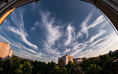
Sony A7C & TTArtisan 11mm F2.8 ED Fisheye, interval 5 seconds, speed 150x
20230604_1740-1955utc_Kacerov_1728x1080.mp4 (115 MB)
Evening cirrus clouds, as observed from Kačerov, Prague, Czech Republic, southward view.
See also images loops from the MSG4 (Meteosat-11) satellite, taken in RSS mode (5-minute scans) in the CE_VIS-IR and CZ1KM_HRV formats, and static images from NOAA-19 satellite taken just after sunset, Central Europe (VIS-IR) and Czech Republic (NM-RGB) formats. In the Meteosat images, the highest clouds (here cirrus) appears to be located more northward than in reality, due to parallax shift (slant view from the geostationary orbit).
Sony A7C & TTArtisan 11mm F2.8 ED Fisheye, interval 20 seconds, speed 600x
20230810-11_1945-0030utc_Jankovska-Lhota_x264_1620x1080.mp4 (65 MB)
Chasing Perseids between satellites and airplanes ... or most of what you can see flying in this timelapse are NOT Perseids (see the comments below).
Due to the not very favorable weather forecast for the "Perseid night" on 12/13 August this year I tried to go out two days earlier, on 10/11 August, to my favorite location near Jankovská Lhota, close to Votice (south-central Bohemia, Czech Rep.). Until midnight it was partially cloudy, clearing out later on. Despite the bad conditions I managed to capture several rather faint Perseids. Later in the night, the timelapse also shows nice onset of a green airglow and waves in it, propagating from various directions. Southward view, with city of Tábor shining at south.
21:53 CEST - A brighter Perseid (in the right part of the image), still at dusk. The other two shorter lines are aircraft tracks.
22:13 CEST - All the lines in this image are just satellite and aircraft tracks. They can be easily distinguished from Perseids - while a Perseid (or generally, any meteor or bolide) is captured in a single frame only, aircraft and satellites can be traced in several images in a row - which is the vast majority of what is seen in this timelapse. .
23:20 CEST - Another Perseid on the left, satellites on the right.
00:03 CEST - The sky finally started to clear...
00:59 CEST - Shortly after midnight, the sky began to brighten - both due to a green airglow (the video also shows various waves advancing from different directions) and with the diffuse glow of the rising Moon crescent .
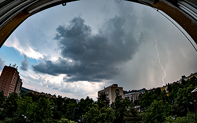
Samsung NX 500 & Samyang 8mm F2.8 UMC Fisheye II, interval 4 seconds, speed 160x
20230816_1500-1655utc_Praha-Kacerov_x264_1728x1080.mp4 (94 MB)
Storm above southwest Prague (Czech Republic), captured from Kačerov, southward view.
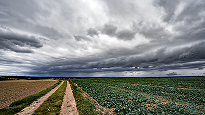
Sony A7C & Sigma 17 mm F4 DG DN Contemporary, interval 3 seconds, speed 90x
20231014_1040-1140utc_Okrouhlik.mp4 (87 MB)
Autumnal shelf cloud (if this term can be used in this case) over Prague, during passage of a cold front. In the MSG satellite images, there were several distinct convergence lines, resembling ropes, from early morning hours, and the time of transition of one of them corresponds to the captured phenomenon (although at the time of the timelapse it is hidden under higher clouds). Also in radar data there was a distinct linear formation of high radar reflectivity in the morning hours, but it broke up as it moved eastwards and was no longer visible over the area at the time of the timelapse (the place and time of the timelapse are marked with a red dot). Overpass of the phenomenon was accompanied by a drop of temperatuere, change of wind direction and speed, and onset of precipitation - see the weather record from nearby Prague-Libu Observatory (time of the timelapse is marked here with a black rectangle). See also one static image from the timelapse, when the phenomenon was probably best pronounced. Taken from Okrouhlik near Kříkový Újezdec, central Bohemia.
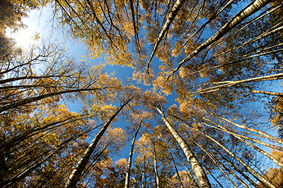
Samsung NX 500 & Samyang 8mm F2.8 UMC Fisheye II, interval 5 seconds, speed 150x
20231112_1113-1221utc_Okrouhlik_1620x1080.mp4 (63 MB)
Look up! Fall colors of birch forest, Okrouhlík, central Bohemia.
Samsung NX 500 & Samyang 8mm F2.8 UMC Fisheye II, interval 5 seconds, speed 150x
20231112_1243-1356utc_Ovcarsky-rybnik_1920x1080_x264.mp4 (81 MB)
20231112_1243-1356utc_Ovcarsky-rybnik_1920x1080_x265.mkv (88 MB, H.265)
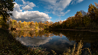
Fall reflections in Ovčáry, first pond on Botič Creek, about 400 meters down from its spring. Okrouhlík, central Bohemia (map here).
See also two static photos at higher resolution - first one from the timelapse, taken by Samsung NX500 (with lens Samyang 8mm F2.8 UMC Fisheye II), and the second one taken by Sony A7C (lens Sigma 17 mm F4 DG DN Contemporary) from the right bank of the pond.
Samsung NX 500 & Samyang 8mm F2.8 UMC Fisheye II, interval 5 seconds, speed 150x
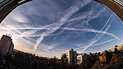
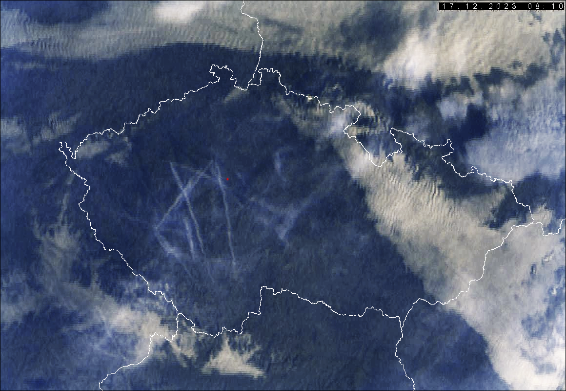
20231217_0742-0914utc_contrails-Kacerov_1920x1080_x264.mp4 (80 MB)
Condensation trails (contrails), Prague - Kačerov, view to the southwest. See also two static images from about the same time - Sony A7C and Sigma 17mm (08:08 UTC) and the other one from timelapse, Samsung NX500 and Samyang 8mm (08:07 UTC). For comparison, see also an image from above, from Meteosat-11 (MSG4) satellite from roughly the same time (08:10 UTC, RGB VIS-IR), and an combined image loop from Meteosat-11 (scanning at 5 minute intervals) and Meteosat-10 (MSG3) at 15 minute steps (MSG4 was scanning at 5 minute Rapid Scan until 08:35 UTC only, when the regular two-day Rapid Scan outage started - hence the second part of the animation is only at coarser steps), and shorter, more detailed animation from MSG4 (5-minute scan in HRV channel) only.
Samsung NX 500 & Samyang 12mm F2.0 NCS CS, interval 8 seconds, speed 240x
20231231_0640-0840utc_Vysehrad_1920x1080.mp4 (45 MB)
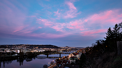
Last morning of 2023 ... Pre-frontal cirrus clouds (propagating eastward) above Prague, taken from Vyehrad, northward view. See also the satellite MSG-RSS VIS-IR loop (red dot indicates place and time of the timelapse).