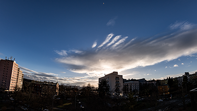
Samsung NX 500 & Samyang 8mm F2.8 UMC Fisheye II, interval 4 seconds, speed 120x
20240101_1345-1503utc_Kacerov_1920x1080_x264.mp4 (85 MB)
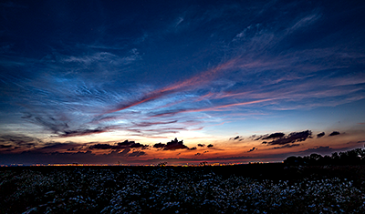
Cloud waves above Praha.
Determining the height of this and subsequent waves is somewhat uncertain. According to the High Resolution Visible (HRV) channel images from Meteosat-11 (MSG-4, Meteosat Second Generation), the individual waves in the wider area over the Czech Republic seem to cast shadows on a lower, more continuous cloud layer - see this HRV image from the beginning of the timelapse, in which the wave shown in the timelapse is marked with a green arrow, along with the location and angle of the timelapse, and the HRV loop, in which the location of the imaging location is marked with a white cross, and its red color indicates the time of the timelapse. According to lidar observations (source: EUMETNET e-Profile) from nearby Praha-Libu, the continuous cloud layer is at levels around 1.5 to 2 km - so the waves must be higher above it. The midday (12 UTC) atmospheric sounding (also from Praha-Libu) indicates a possible additional cloud layer at around 4 km - which might be the level of the waves.
See also this larger photo of the wave from 13:52 UTC, when the wave was most "photogenic".
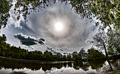
Samsung NX 500 & Samyang 8mm F2.8 UMC Fisheye II, interval 4 seconds, speed 120x
20240414_1145-1313utc_Ovcary_cirrus-and-dust_1760x1080_x264.mp4 (156 MB)
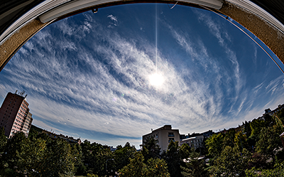
Cirrus and dust - game of shadows.
On that day, a narrow band of Saharan dust was passing over western and central Europe, getting here from the Atlantic - see the mosaic of Aerosol Index Product (source: Copernicus Browser), composed of several subsequent passes of the Sentinel-5P satellite. Part of the dust band (indicated by the arrow) is also visible over NW France in the RGB-24M image product from the NOAA-20 satellite, disappearing under a layer of cirrus clouds further inland above central Europe. Animations of the VIS-IR and RGB-24M images from the Rapid Scan mode of the MSG satellite show the situation over central Europe on that day, with a jet stream drifting the cirrus clouds rapidly to the east (see also the 12 UTC sounding from Praha-Libu station).
The Saharan dust layer is very well visible in the ALC profile from Praha-Karlov station (source: EUMETNET E-PROFILE), where it is marked with the number [3]. The number [1] indicates the surface aerosol layer (of a local origin), [2] the layer in which shallow convective clouds (cumulus) were present at the time of the timelapse (indicated by vertical lines and double arrow), [4] indicates the cloud-free clear layer between the Saharan dust and the cirrus levels [5]. The NOAA-20 image at 375 m resolution shows in detail the cirrus clouds over the Czech Republic, their large horizontal variability. These cirrus clouds are both of natural origin as well as remnants of airplane condensation trails (contrails).
Now to the timelapse itself. It is a result of heavy computer processing of the original images, which themselves showed almost no detail - see the original image (as shot) and the same image after processing from a raw file in Lightroom. In the timelapse, notice especially the rapidly advancing shadows of the cirrus clouds, cast into the layer of Saharan dust. In the detailed image of the contrail shadows, numbers [1] and [2] indicate shadows cast on two nearby layers of cirrus clouds (the plane must have been flying just above these), and [3] indicates the contrail shadow cast into the Saharan dust layer. As can be seen very nicely from this slower animation of the contrail shadows, the relative position of the shadow (including its beginning) to the contrail itself depends on the actual position of the airplane and its contrail relative to the Sun and the location of the observation.
Besides the shadows, notice also the motion of larger cumulus clouds along a horizontal helix, caused by strong vertical wind shear at the cumulus levels, approximately between 2 and 3 km above the ground.
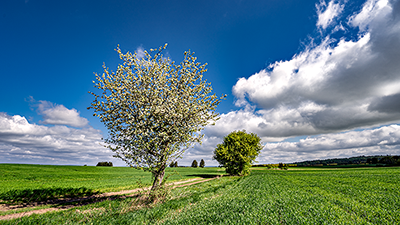
Sony A7C & Sigma 17 mm F4 DG DN Contemporary, interval 3 seconds, speed 90x
20240417_Mandava_x264_1920x1080.mp4 (47 MB)
Spring.
Mandava and Okrouhlík, south of Prague, Czech Republic.See also this photo from the timelapse series.
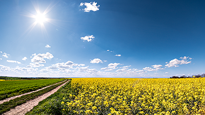
Samsung NX 500 & Samyang 8mm F2.8 UMC Fisheye II, interval 6.5 seconds, speed 195x
20240427_1405-1500utc_Okrouhlik_x264_1920x1080.mp4 (54 MB)
Yellow and blue.
Okrouhlík, south of Prague, Czech Republic. See also this photo from the timelapse series.
Sony A7C & Sigma 17 mm F4 DG DN Contemporary, interval 4 seconds, speed 120x
20240628_2000-2115utc_NLC_Okrouhlik_x264_1920x1080.mp4 (96 MB)
NLC (noctilucent clouds) and cirrus clouds above Prague, captured from slopes of Okrouhlík (south of Prague).
The NLC begin to gradually appear in the left part of the video as the sky darkens and the Sun dips below the northwest horizon. NLC can be easily distinguished from tropospheric clouds (especially cirrus) by their gradual westward drift (toward the left), while cirrus and remnants of convection move more rapidly eastward (to the right in the image). As the Sun sinks deeper and deeper below the horizon, the apparent height of NLC above the horizon decreases (as the Earth's shadow height increases in the upper mesosphere, about 85 km above the Earth's surface, where NLC occur). See also the static image from 20:30 UTC (21:30 CEST), when the NLC were probably most prominent, and the OSWIN mesospheric radar record (source here). And one more image, from 20:45 UTC - what looks like a greenish hair here is a trail of firefly flying in front of the lens.

Sony A7C & Sigma 17 mm F4 DG DN Contemporary, interval 4 seconds, speed 120x
20240708_2005-2115utc_NLC_Praha.mp4 (76 MB)
NLC (noctilucent clouds) above historical center of Prague, captured from Most Legií.
See also a photo from 20:32 UTC (22:32 CEST), and OSWIN radar record (source here). In this case, though, I'm a little worried that most of you who watch this timelapse will be following the pedal boats on the Vltava River rather than the noctilucent clouds

A timelapse of probably the best NLC I have ever seen (and timelapsed) is here: 2020-07-05.

Sony A7C & TTArtisan 11 mm F2,8 ED Fisheye, interval 20 seconds, speed 600x
20240729_1950-2300utc_Libesov_x264.mp4 (45 MB)
Milky Way above southern-central Bohemia.
Nothing that much interesting here, just a display of strong air traffic over the area, accompanied by lots of fainter satellites, and cows grazing on the horizon to the right. Couple of Perseids, the brightest one in this image, to the left of the Milky Way (all the other lines are aircraft and satellite tracks). Taken from hillside of Libeov, close to Sedlčany. The town is on the horizon on the far left, with Cihelný vrch right of them, next bright blob comes from Tabor, accompanied by lights of distant České Budějovice (close to the frame center).
Samsung NX 500 & Samyang 8mm F2.8 UMC Fisheye II, interval 5 seconds, speed 225x
20240908_1110-1510utc_Kacerov_x264_1740x1080.mp4 (137 MB)
End of summer, fall begins.
Prefrontal cloudiness on a cold front, which terminated the hot summer of 2024. Recorded from Praha - Kačerov, Czech Republic, southward view.
At first glance, this looks as a boring, uninteresting timelapse - which nevertheless hides several meteorological features of interest. First of all, a distinct vertical wind shear can be noticed - while cirrus clouds at 11-12 km levels propagate quickly eastward (from right to left in the shot), low, small cumulus clouds drift from SE to NW (approximately from left to right in the shot). Next, at the end of the timelapse sequence, we can observe significant slowdown of motion of clouds. This is caused by decrease of height of the cloud base, down to about 8 km, where the winds are already significantly slower. The height of the cloud base can be retrieved from ALC profiles (Automated Lidars and Ceilometers, source: EUMETNET E-PROFILE) of clouds and aerosols, and the speed and direction of the flow at different levels from the noon sounding from Prague-Libu. Another interesting feature are the semitransparent cumulus clouds (circled in this example), formed by tiny water droplets, on tops of some of which further condensation occurs, leading to formation of regular small opaque cumulus clouds. Throughout the timelapse, a solar halo can also be observed. To conclude, here is a view from above, from the new MTG-I1 (Meteosat Third Generation - Imager) satellite and its FCI (Flexible Combined Imager) instrument in two new RGB image products: RGB True Color (Europe, Central Europe, Czech Republic) and RGB Cloud Type (Europe, Central Europe, Czech Republic); all of these are based on pre-operational data. The red dot in the Czech Republic format indicates the location and time of the timelapse.
Sony A7C & Asahi Takumar SMC 55mm F2 (F/2.8), interval 10 seconds, speed 300x
20241015_1700-1755utc_C2023-A3-Tsuchinshan-ATLAS_Kacerov_x264_1440x1080.mp4 (30 MB)
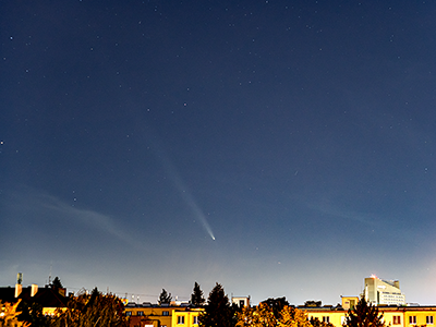
Comet C/2023 A3 Tsuchinshan-ATLAS.
Captured from a window of our apartment at Kačerov, Prague, Czech Republic.. Besides the light pollution, the bright sky was also illuminated by the Moon being only two days before its full phase.

Sony A7C & Sony SEL2860 (@28mm F/4), interval 5 seconds, speed 225x
20241016_1547-1815utc_C2023-A3-Tsuchinshan-ATLAS_Okrouhlik_x264_1728x1080.mp4 (88 MB)
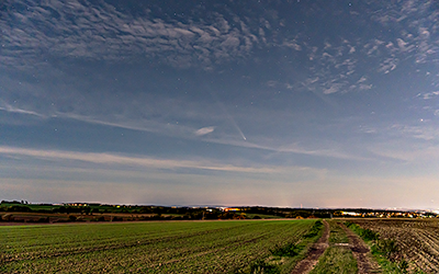
Cloud wave and comet C/2023 A3 Tsuchinshan-ATLAS at full moon.
When I was leaving home for Okrouhlík (near Kříkový Újezdec, south of Prague, CZ) to try a timelapse of the comet under slightly darker sky, it looked quite promising in terms of cloudiness. But before I managed to get there, a large cloud wave started to form, stretching from Novohradské hory to Kruné hory, see the images from Meteosat satellites in the 24-hour microphysics RGB product, from the second and third generations of these satellites, MSG-SEVIRI_CZ1KM_24M and MTG-FCI_CZ1KM_24M. The impact of better resolution of the Meteosat Third Generation (MTG) is obvious. In both images, the location of place from which I was timelapsing and the approximate angle of view of the camera are marked. See also animations from the three Meteosat satellites: MSG3_FES_24M, MSG4_RSS_24M and MTG-I1_FCI_24M. Please note that the images from MTG-I1 are from pre-operational data of this satellite, and therefore still contain some raw data processing artifacts, which EUMETSAT will hopefully be able to fix later on.
The wave was gradually growing, so I accepted the fact that I will be timelapsing this wave instead of the comet. Eventually, the wave began to dissipate after dark, with rising glowing moon (a day before the full moon) on the other side of the sky. Finally, the comet showed up over the moonlit landscape for a while. See also several static images of the wave and the comet: 15:51 UTC (17:51 CEST), 16:10 UTC (18:10 CEST), 17:05 UTC (19:05 CEST) and 17:50 UTC (19:50 CEST).
The wave was gradually growing, so I accepted the fact that I will be timelapsing this wave instead of the comet. Eventually, the wave began to dissipate after dark, with rising glowing moon (a day before the full moon) on the other side of the sky. Finally, the comet showed up over the moonlit landscape for a while. See also several static images of the wave and the comet: 15:51 UTC (17:51 CEST), 16:10 UTC (18:10 CEST), 17:05 UTC (19:05 CEST) and 17:50 UTC (19:50 CEST).

Samsung NX 500 & Samyang 8mm F2.8 UMC Fisheye II, interval 5 seconds, speed 150x
20241130_1100-1247utc_Kacerov_x264_1920x1080.mp4 (94 MB)
Turbulent atmospheric boundary layer.
Similarly to the timelapse from 2024-09-08 above, we can observe here semi-transparent cumulus clouds, consisting of small aerosols, the germs of larger water droplets (see also this static image from 11:19 UTC). The formation of regular cumulus can then be observed at the tops of some of these "aerosol cumulus" clouds. These aerosol cumulus clouds can only be observed in directions towards the sun, where forward scattering of the sun's rays is more pronounced.
See also the image from NOAA-20 satellite, taken at 11:35 UTC (during the timelapse), RGB TrueColor composite of channels M5, M4 and M3, where the cross indicates location from which the timelapse was taken (Prague, Kačerov, southward view. It shows that there were indeed only very few cumulus clouds around at that time. Both the noon sounding from Prague-Libu and the ALC profile from Prague-Karlov (in which the arrow indicates the time span of the timelapse) show that the upper boundary of the layer in which the observed convection took place was about 1.5 km above the ground.

Samsung NX 500 & Samyang 8mm F2.8 UMC Fisheye II, interval 8 seconds, speed 240x
20241229_0840-1110utc_Kacerov_x264_1760x1080.mp4 (84 MB)
Dissolution of the morning fog above Krč valley, Prague. See also the animation of MTG images for the whole day (red cross indicates the location of the shooting location, Kačerov), RGB product CloudType. In this product from the FCI instrument, light blue represents low clouds and fog, green snow-covered terrain, dim greenish indicates terrain covered with frost on vegetation, dark blue cloudless bare terrain, reddish thin cirrus. Note how after sunrise most of the terrain, where it was clear, is covered with frost, which disappears during the day. See also the static image from 09:31 UTC and a detailed image from the Sentinel-3 satellite (OLCI instrument) from 09:43 UTC (image source: Copernicus).