
Samsung NX 500 & Samyang 8mm F2.8 UMC Fisheye II, interval 5 seconds, speed 150x
20250309_1530-1630utc_Bohdanec_x264_1920x1080.mp4 (56 MB)
Pre-spring silhouettes and reflections. Bohdaneč Pond, Lázně Bohdaneč (district of Pardubice, Czech Republic).
See also a static photo from the beginning of the timelapse and MTG-I1 (Meteosat Third Generation), Meteosat-12 satellite loops RGB VIS-IR, and RGB Cloud Type (CHMI version) image products. The area was somewhat covered by dust, as can be seen in the ALC profile from nearby Ústí nad Orlicí. The two black vertical lines indicate time span of the timelapse.

Sony A7C & 7Artisans 10mm F2.8 II Fisheye ED, interval 12 seconds, speed 120x
20250321_1830-1926utc_Sulice_normal-mode_x264_1620x1080.mp4 (65 MB)
20250321_1830-1926utc_Sulice_startrails-mode_x264_1620x1080.mp4 (65 MB)
Satellite tracks through the night sky. While some thirty years ago, when I was active in astrophotography, satellite passes through the night sky were rather a rarity that all of us got excited about, today satellites pose a serious problem for wide-angle astrophotography, especially when timelapsing the night sky. Satellites can be removed from a static photo by various methods, but for timelapses this would already be a challenging problem. Fortunately, the Earth itself helps here (to a certain degree) - when satellites enter its shadow, they are no longer visible.
This can be clearly seen in the timelapse above: the satellites flying from the right side of the frame (west) do not reach the left side, southeast part of the image. The same is true for satellites flying in polar orbits (from south to north or vice versa), they only appear or disappear at some distance from the left edge of the frame. Moreover, it is possible to notice how this whole satellite darkness area slowly drifts westwards (to the right, towards the center of the frame). This is nothing else than the Earth's shadow - when the satellite enters it, it ceases to be visible (and vice versa). The only trails that make it all the way to the left edge are planes - they usually also have dotted tracks (a result of blinking of their position lights). All of this is nicely visible on both the classic (normal) timelapse and the startrails version (from about a third of the timelapse onward). See also this static image of startrails, in which the satellite (and aircraft) tracks are shown at their full length. The short gaps in the satellite trails are gaps between the timelapse frames. Another thing to notice is that the satellites do not disappear at any precise location - this is due to the fact that they fly at different altitudes, and the position of the Earth's shadow depends on its height above the surface. Satellites on the lowest orbits disappear most quickly after the sunset, while the higher ones disappear later (if at all).
The last thing that makes this timelapse interesting is the blue color of some of the satellites. In the entire timelapse (just under one hour) I found about seven of them in the images. These might be the newer generation Starlinks, coated with a special coating to reduce their reflectivity (see e.g. info here). Though, I don't know for sure.
Samsung NX 500 & Samyang 8mm F2.8 UMC Fisheye II, interval 8 seconds, speed 240x
20250322_1110-1420utc_Kacerov_x264_1920x1080.mp4 (103 MB)
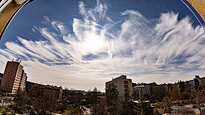
Cirrus clouds above Prague, on their way to Central Europe. See also a still photo from 11:35 UTC, time of NOAA-20 overpass above the area, from which are the following image products: True Color RGB (VIIRS bands 5,4,3), 24h Microphysics RGB, Cloud Phase RGB, Cloud Type RGB, and the 1.38 μm band M9 image.
Motion of the cirrus band as captured by Meteosat-12 (MTG-I1, Meteosat Third Generation - Imager 1): True Color RGB, Cloud Phase RGB and Cloud Type RGB (CHMI version). Red dot indicates place and time of the timelapse.
For interpretation of these VIIRS and MTG RGB image products and bands see e.g. the EuMeTrain Quick Guides.

Samsung NX 500 & Samyang 8mm F2.8 UMC Fisheye II, interval 4 seconds, speed 120x
20250601_1735-1815utc_x264_1920x1080.mp4 (48 MB)
Weak shelf cloud on dissipating thunderstorms and showers (see this radar image) above southern parts of Prague, Czech Republic. Static image from 17:50UTC here.

Samsung NX 500 & Samyang 8mm F2.8 UMC Fisheye II, interval 30 seconds, speed 900x
20250611-13_Klementinum_1728x1080_x264.mp4 (204 MB)
Prague - Klementinum weather station celebrates 250 years of continuous air temperature measurements this year, though the first measurements (with gaps) started already somewhat earlier, in 1772. Other variables began to be measured continuously later on, or have gaps in their series. Klementinum (Clementinum), famous for its Astronomical Tower and Baroque Library, is thus the oldest continuously measuring weather station in the Czech Republic and one of the oldest in Europe. The current station has two locations in Klementinum - the historic one in a first-floor window on the north side of the south wing of the complex (location of the station in photo is marked here), the other one on a platform on the roof of the east wing. More information on the history of the meteorological measurements at Klementinum can be found e.g. here (CHMI) or here.
The timelapse captures illumination of the station in a window during the day, shortly before the summer solstice, when the sun is at its highest and also at its northernmost point on its journey across the sky. Thus, twice a day in spring and summer (after sunrise and before sunset) the sun shines directly on the station, partially shaded by the astronomical tower in the afternoon. The bright source of light traveling in the night low in the southwestern sky is full moon. Westward view from the roof platform.

Samsung NX 500 & Samyang 8mm F2.8 UMC Fisheye II, interval 5 seconds, speed 150x
20250615_1551-1710utc_Okrouhlik_x264_1700x1080.mp4 (71 MB)
Turbulent sky. Weak dissipating outflow boundary (?) south of Prague. See also still image from 16:31 UTC, the radar image from 15:55 UTC with an arrow indicating the boundary, radar loop from 13:30 - 18:00 UTC (with indication of place and time of the timelapse, and its sector), and MTG satellite loop of IR10.5 sandwich product (rather uninteresting for these storms).
Sony A7C & Sony SEL2860 @ 28mm, interval 4 seconds, speed 120x
20250711_1403-1536utc_Velka-Javorina.mp4 (101 MB)
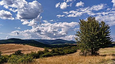
Veľká Javorina. Highest peak (970 m) of the White Carpathians mountain range at Moravian/Slovak borders. View from south, from a hill Chrásť above Bzince pod Javorinou, district of Nové Mesto nad Váhom, western Slovakia. Larger static photo here.
Sony A7C & Sony SEL2860 @ 28mm, interval 4 seconds, speed 120x
20250801_1550-1802utc_Okrouhlik_x264_1920x1080.mp4 (140 MB)
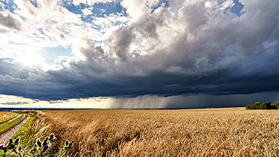
Showers above Prague (CZ) and its surroundings Taken from Okrouhlík, NW view. See also this larger photo, taken with a fish-eye lens on my other camera.

Samsung NX 500 & Samyang 8mm F2.8 UMC Fisheye II, interval 5 seconds, speed 150x
20250807_0419-0824utc_Kacerov_cirrus-in-B&W_x264_1800x1080.mp4 (208 MB)
Cirrus clouds in 256 shades of gray. The high variability and diversity of cirrus clouds over a four-hour period was most likely related to the presence of large amounts of smoke from Canadian fires over Central Europe. Smoke particles act as condensation or crystallization nuclei; given their altitude in this case of up to 12 km, they act as cirrus cloud nuclei. This is clearly visible in the ALC profiles (Automatic Lidar Ceilometers), available, for example, from the EUMETNET e-Profile network. The extent of the smoke from the fires is then highlighted in satellite images from the MTG satellite and its FCI instrument, in the RGB TrueColor product. It uses short-wave channels VIS04, VIS05, and VIS06, which are significantly more sensitive to the presence of aerosols (smoke, dust from fires or volcanic eruptions, pollen, small salt crystals, or small droplets) than other FCI channels operating at longer wavelengths. Dust layers are particularly prominent when illuminated by the Sun low above the horizon. Transport of the dust from Canada fires across the Atlantic Ocean to Europe is clearly visible in the animation of aerosol products (dark red) from MODIS and VIIRS instruments. In black and white, the 3D structure and dynamics of cirrus clouds also stand out much better, resulting from different motion of cirrus layers depending on their height and wind profile, seen in the sounding from Praha-Libu station taken on this morning.
The sequence was converted to greyscale in Adobe Photoshop, with significant suppression of the original blue component in the source images.

Sony A7C & Sonnar 3.5/135 MC (Carl Zeiss Jena), interval 2 seconds, speed 60x
20250812_1810-1827utc_dusty-sunset_Okrouhlik-Klinovec_x264_1920x1080.mp4 (27 MB)
Sunset behind Klínovec, 1244 m, highest mountain of Kruné hory (Erzgebirge), captured form 125 km distant Okrouhlík (488 m, small hill south of Prague), see this map and also this image. This constellation occurs twice a year, when the Sun sets at azimuth 294° (WNW) - besides the 12-13 August (as in this case), also on 28-29 April.
The visibility of Klínovec requires relatively clear air between the location from which the timelapse was taken and Klínovec, as well as absence of any clouds (both in front of and behind Klínovec). Both conditions were met in this case, as shown in this True Color RGB image from the MTG-I1 (Meteosat-12) satellite, taken approximately 2 hours before sunset. Among other things, it also shows dust (smoke from fires in Canada) covering Germany from the west and beginning to spread above our territory.

Samsung NX 500 & Samyang 8mm F2.8 UMC Fisheye II, interval 5 seconds, speed 150x
20250812_1739-1836utc_Okrouhlik-sunset_fisheye_rgb.mp4 (33 MB, color version)
20250812_1739-1836utc_Okrouhlik-sunset_fisheye_greyscale.mp4 (33 MB, greyscale version)
Ripply dusty sunset. Simultaneously with my timelapse of the sunset behind Klínovec (see above), I used a wide-angle lens on my second camera to record a timelapse of clouds of dust (smoke from Canadian fires) drifting from the west over Czechia. Their structure was interesting in addition to the distinctive "fibers", faintly visible to the naked eye, smaller ripples formed on the veil of dust, which only stood out in the timelapse movies. The timelapse is processed both in color (with only slight enhancement of the structures) and in black and white, where the structure of the dust stands out very nicely due to the significant suppression of the blue component. See also static images from 18:05 UTC (20:05 CEST) in color and in black and white versions. Taken from Okrouhlík, south of Prague.
In images from meteorological satellites, dust clouds are typically best seen either early morning, shortly after sunrise, or in the late afternoon, before sunset see the animation of images from MTG-I1 (Meteosat Third Generation) in the RGB TrueColor product (12-18 UTC). These dust clouds stand out even better in images taken by Meteosat-9, which is located above the western Indian Ocean and thus "looks" at the dust over Europe almost against the setting sun, resulting in strong forward scattering of light on the dust particles. See also the last image from this satellite from 18:00 UTC (slightly more enhanced). Finally, the vertical structure of the dust is clearly visible in the time slice from ALC lidars over Germany, near Czechia western border. In it, the green vertical lines define the interval of the animation from MTG-I1, and the double arrow indicates the timelapse interval (the reason for using these two German lidars is their significantly better quality compared to our older lidars). ALC source: EUMETNET eProfile.
In images from meteorological satellites, dust clouds are typically best seen either early morning, shortly after sunrise, or in the late afternoon, before sunset see the animation of images from MTG-I1 (Meteosat Third Generation) in the RGB TrueColor product (12-18 UTC). These dust clouds stand out even better in images taken by Meteosat-9, which is located above the western Indian Ocean and thus "looks" at the dust over Europe almost against the setting sun, resulting in strong forward scattering of light on the dust particles. See also the last image from this satellite from 18:00 UTC (slightly more enhanced). Finally, the vertical structure of the dust is clearly visible in the time slice from ALC lidars over Germany, near Czechia western border. In it, the green vertical lines define the interval of the animation from MTG-I1, and the double arrow indicates the timelapse interval (the reason for using these two German lidars is their significantly better quality compared to our older lidars). ALC source: EUMETNET eProfile.

Sony A7C & Sigma 17 mm F4 DG DN Contemporary, interval 20 seconds, speed 240x
20250916_1824-1950utc_MW_Kvilda_x264.mp4 (50 MB)
Milky Way above umava, south Bohemia, from Kvilda, captured from a balcony of our accommodation at Holiday house Kvilda - Vilémov. The reddish trees in the foreground are illuminated by street lights of Kvilda. See also this static image from 19:25 UTC (21:25 CEST). The horizon is light-polluted by city lights from neighboring Germany. In addition to numerous planes and satellites, a faint green airglow can also be seen slowly drifting from the west (from right). Southward view.
This timelapse was originally ment to be just a test for the timelapse below (from September 18, 2025), which is why it is so short. Also, I stored it at slower 12 fps for playback to make it easier to see all the heavy air traffic in the corridor around the German border, as well as many satellites, visible namely in the first half of the timelapse, before the satellites at the lowest orbits disappeared in the rising Earth's shadow.

Sony A7C & Sigma 17 mm F4 DG DN Contemporary, interval 20 seconds, speed 600x
20250918_1625-2105utc__MW-Kvilda_x264_1600x1080.mp4 (65 MB)
Milky Way and green airglow above umava, south Bohemia. Taken from a forest glade above Kvilda (see the orthophoto and position on the map, source Mapy.com), where the lights from Kvilda itself are no longer a big issue, but the light pollution over Germany (towards Passau, source lightpollutionmap.info) is rather strong. The location and angle of the timelapse are marked in red on both images. Compared to the night of September 16, 2025, there was a thicker haze above the horizon, significantly intensifying the glare of the horizon. See also these static photos from 16:26 UTC (18:26 CEST) shortly before sunset, 18:48 UTC (20:48 CEST) shortly after dusk, and 21:02 UTC (23:02 CEST) from the end of the timelapse, both night ones after filtering out airplanes and satellites.
It's a pity I didn't know about the presence of green airglow (natural emission of atomic oxygen at altitudes between 90 and 100 km above the ground, near the mesopause) at the time of shooting, otherwise I would have stayed there longer. Airglow, whether green or red, is not visible to the naked eye because it is too faint; the eye perceives it only as a colorless, lighter veil or bands in the sky. Its colors only stand out in processed photographs.

Sony A7C & Sony SEL2860 @ 28mm, interval 1 second, speed: 20x
20251023_0543utc_rainbow_Kacerov_x264_1080x1080.mp4 (25 MB)
20251023_0543utc_rainbow_Kacerov_x265_RGB24_1080x1080.mkv (25 MB, HEVC RGB24)
Fine structure of a sunrise rainbow. As can be clearly seen in the beginning of the timelapse or in this larger still photo of the rainbow, in addition to the main rainbow arc and the relatively common weaker secondary arc (outside the main arc), there were also two, possibly three so-called supernumerary bows (or bands), closely adjacent to the main arc from its inner side. For an explanation of these supernumerary bands, see e.g. Wikipedia. The timelapse clearly shows the significant temporal variability of the appearance of both, the main and secondary rainbows, and especially the aforementioned inner supernumerary bands. Unfortunately I missed the beginning of the rainbow, but at least I managed to capture its most beautiful phase, until its disappearance - all within a span of just four minutes. The HEVC RGB24 version of the timelapse is slightly higher quality (in fine details), but probably you will need an external video player to play it (web browsers do not support this format). Location: Prague - Kačerov.
Sony A7C & Sony SEL2860 @ 35mm, interval 5 seconds, speed: 150x
20251229_1330-1500utc_Praha-Libus_x264.mp4 (78 MB)
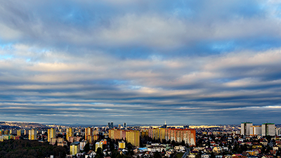
Cloud waves above Czechia, taken from Prague. In this case, I first noticed the beautiful waves in satellite imagery, taken by Meteosat-12 (MTG-I1), and only afterwards in the sky. I recommend playing the satellite image animation (VIS0.6 band at half-kilometer resolution) several times over and over, until you begin to perceive several different groups of waves, generated by different sources and interfeeing with each other. The still images from the satellite (1400utc MTG FCI VIS06) and from the Praha-Libu ex-radar tower (Sony A7C 13:57 UTC) were taken at almost the same time, around 14:00 UTC (15:00 CET), with the red dot in the satellite image marking the location from where the timelapse was taken. The base of the cloud layer was (above Prague) at altitude of around 1 km, as shown by the noon sounding from Praha- Libu. Some of the waves are of orographic origin (flow over mountain ridges), while other ones are most likely caused by strong vertical wind shear (a change in direction and speed below and above this cloud layer).