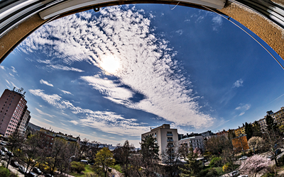
Samsung NX 500 & Samyang 8mm F2.8 UMC Fisheye II, interval 5 seconds, speed-up 150x
20260402_1005-1200utc_Kacerov_x264_1800x1080.mp4 (100 MB)
Wave of altocumulus clouds above Prague.
See also comparison of this image from the Sentinel-2B satellite (Highlight Optimized Natural Color image, with native pixel size of the used MSI bands 10m, showing location from which the timelapse was captured, and its angle of view) and a ground-level shot from the timelapse series, both taken at the same time (10:16:50 UTC). Thanks to the high resolution of the MSI instrument, individual altocumulus clouds are clearly visible in the image it captured. Though, despite the fact that both images were taken at the same time, it is impossible to co-locate the individual altocumulus clouds in these. For comparison, attached are images from the FCI instrument on the Meteosat-12 satellite (MTG-I1) from the same time: RGB True Color, RGB Cloud Type (CHMI), RGB Cloud Phase (CHMI), RGB VIS-IR and VIS 0.6. The cloud wave is visible in all of these, but without any structure within it (the resolution of these images is 0.5 and 1 km). Animations of the RGB True Color and RGB Cloud Type (CHMI) images show significant temporal variability of the wave, which corresponds to the development seen in the time-lapse. Small red cross in MTG images shows the location from where the timelapse was taken (Praha - Kačerov, Czechia).
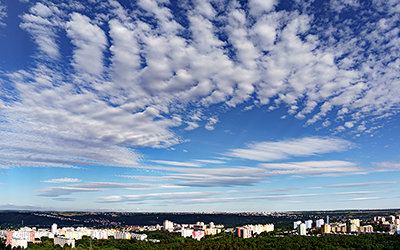
Sony A7C & Sony SEL2860 @ 28mm, interval 4 seconds, speed-up 120x
20260709_0545-0700utc_Praha-Libus.mp4 (40 MB, color version)
20260709_0545-0700utc_Praha-Libus_bw.mp4 (30 MB, greyscale version)
Wave clouds generated by the Ore Mountains, as observed from Prague.
The overall weather situation is nicely illustrated in this loop of RGB True Color images from Meteosat-12 (MTG-I1) satellite, capturing the lee waves from sunrise until their dissipation approximately six hours later. See also these still images from 04:00 UTC (06:00 CEST) and 05:40 UTC (07:40 CEST). The waves formed as a result of interaction of very strong, nearly northerly winds (see the Libuš sounding from 06 UTC), with a ridge of the Ore Mountains. According to lidar measurements, their height was about 5 to 6 km.
The time-lapse itself is available here in two versions — the original color version, and strongly enhanced black-and-white version. It nicely shows the typical behavior of such orographic waves — while the waves remain nearly stationary, smaller clouds (Ac) flow through them (or rather, form within them and then dissipate again as they leave the wave). The black-and-white version is, among other, a result of strong suppression of the blue component of the original images, which highlights the clouds against the darker background. See also this static color image and the corresponding black-and-white image from 06:00 UTC. Captured from the former weather radar tower at Prague - Libuš.
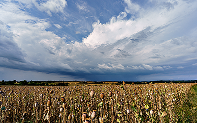
Sony A7C & Sigma 17 mm F4 DG DN Contemporary, interval 4 seconds, speed-up 120x
20260719_0735-1100utc_Okrouhlik.mp4 (76 MB)
Showers south of Prague.
With no storms nearby, at least summer showers. See also several photos from the timelapses: 07:47, 07:59, 09:41, 10:44 and 10:47 (all UTC).
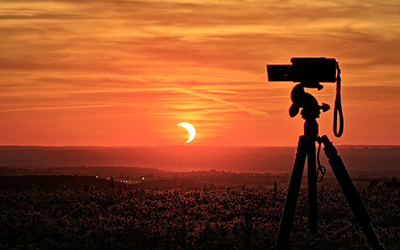
Sony A7C & Sonnar 3.5/135 MC (Carl Zeiss Jena), interval 2 seconds, speed-up 120x
20260812_1731-1833utc_SolarEclipse_Okrouhlik_x264_1620x1080.mp4 (53 MB)
Partial solar eclipse of August 12, 2026.
This time-lapse captures nearly the entire course of the eclipse as it was visible from our region, Central Bohemia. The images were taken through a metal-coated filter (in front of the lens), which, together with the camera’s sensor, reflects the solar crescent — which is symmetrical to the Sun itself. Cirrus clouds, moving over our region from the west, had a significant impact on the eclipse; see the image from MTG (RGB CloudType, where cirrus clouds are shown in red). On the one hand, they made processing of the time-lapse much more complicated; on the other hand, they added a certain sense of drama — see, for example, this still image taken at the peak of the eclipse.
Taken from the Petrovy vrchy hillock, south of Prague. See also this “mood shot” taken with a cell phone.
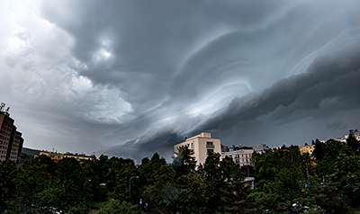
Samsung NX 500 & Samyang 8mm F2.8 UMC Fisheye II, interval 3 seconds, speed-up 60x
20260831_0611-0624utc_shelf-cloud_Kacerov.mp4 (38 MB)
Shelf cloud above southern Prague captured from Kačerov, accompanying weak morning storms. See also two still photos from the timelapse, taken at 06:12 UTC, with asperitas clouds dominating most of the frame and the shelf cloud rising above the western horizon, and just six minutes later, at 06:18 UTC, with the shelf cloud already almost overhead.
In Meteosat-12 (MTG-I1) satellite sandwich (VIS0.6 & IR10.5) image product loop (02:00 - 10:00 UTC) the storms appear as weak, dissipating remains of previous storm activity above Central Europe. In the image from 06:10 UTC (the closest one to the capture time of the timelapse) the red dot indicates place from which the timelapse was taken. The shelf cloud itself can't be seen in the satellite imagery, as it is hidden by higher clouds above.
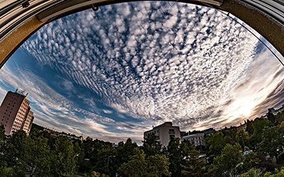
Samsung NX 500 & Samyang 8mm F2.8 UMC Fisheye II, interval 3 seconds, speed-up 60x
20260919_1601-1703utc_Ac_Kacerov.mp4 (70 MB)
Late afternoon altocumulus clouds above southern Prague, captured from Kačerov. See also a static image from 16:11 UTC (18:11 CEST).