 |
2014-01-06
06:25-07:09 & 08:34-09:45 UTC
Ricoh GX100, interval 5 seconds, speed 150x
20140106_0625-0945utc_Praha-Libus.mp4
(61 MB, 1280x720, H.264 / MPEG-4)
20140106_0625-0945utc_Praha-Libus.mpg
(47 MB, 1280x720, MPEG1)
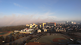
Early morning
fog above south parts of Praha. In
the beginning of the sequence, at the left part of the view, we can see
a typical river valley fog above Vltava River, drifting north, towards
the city center. Later on, increased amounts of advection fog at
somewhat higher levels, brought by stronger winds from south, hide the
view for about one and half hour (skipped in the sequence). In the
second part of the sequence, as the fog gradually dissolves, the
scenery clears again. See also this Metop
image
(data source: EUMETSAT and CHMI) where the red dot indicates the
location from which the sequence was captured - CHMI Observatory Libuš,
Praha, Czech Republic (northward view).
|
 |
2014 - 02 - 20
13:47 - 14:27 UTC (0h 40m)
Ricoh GXR A16, interval 5 seconds, speed 150x
20140220_1347-1427utc_Muscat.mp4
(24 MB, 1280x720, H.264 / MPEG-4)
20140220_1347-1427utc_Muscat.mpg
(23 MB, 1280x720, MPEG1)
Sunset
from Muscat, Oman.
Lecturing for EUMETSAT brings me sometimes to countries, which for most
of us are rather exotic. In this case to Muscat, at the eastern part of
the Arab Peninsula. Given its location at the Tropic of Cancer, the Sun
sets here to hazy and dusty atmosphere much steeper than what we are
used to from central Europe. The mountain at the left part of the frame
is Jebel Shams (3009 m), the highest peak of the Arab Peninsula.
Captured from the Sultan Qaboos University (SQU), Muscat, Oman.
|
 |
2014-04-20
09:25 - 11:31 UTC (2h 06m)
Ricoh GX100, interval 5 seconds, speed 150x
20140420_0925-1131utc_Oblik-Rana.mp4
(65 MB, 1040x720, H.264 / MPEG-4)
20140420_0925-1131utc_Oblik-Rana.mpg
(50 MB, 1040x720, MPEG1)
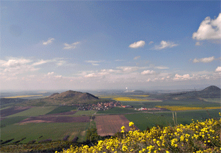
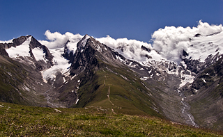
Sky above České středohoří I.
Cirrus clouds and weak shallow convection above southwest part of České
středohoří ( Böhmisches
Mittelgebirge) .
First part of this sequence was captured through IR filter (R72),
second part in regular, visible light. The IR filer significantly
increases contrast of clouds against blue sky, and also all the
vegetaition appears much brighter in IR as compared to normal light
(see also this image, comparing the two spectral bands). Left of the
image center is Raná hill, in its center (further away) is power plant
Počerady.
Captured from the top of Oblík hill (509 m a.s.l.), district
Louny , Czech Republic, westward view.
See several similar older IR cases here. |
 |
2014-04-20
13:29 - 14:13 UTC (0h 44m)
Ricoh GX100, interval 5 seconds, speed 150x
20140420_1329-1413utc_Holy-vrch_Milesovka.mp4
(26 MB, 1280x720, H.264 / MPEG-4)
20140420_1329-1413utc_Holy-vrch_Milesovka.mpg
(20 MB, 1280x720, MPEG1)
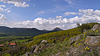
Sky
above České středohoří II.
Shallow convection above central parts of České středohoří (Böhmisches Mittelgebirge).
Almost in center of the frame is Milešovka (837 m a.s.l.), highest hill
of České středohoří. Captured from Holý vrch (458 m a.s.l.) small hill
above Sutom, district Litoměřice, Czech Republic, northwest view.
|
 |
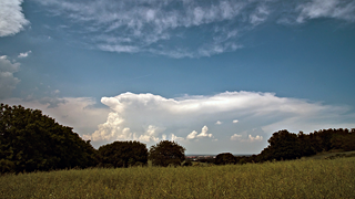
2014 - 04 - 26
11:21 - 12:01 UTC (0h 40m)
Ricoh GXR A16, interval 5 seconds, speed 150x
20140426_1121-1201utc_Oblik_Cb-Klinovec.mp4
(40 MB, 1640x1080, H.264 / MPEG-4)
20140426_1121-1201utc_Oblik_Cb-Klinovec.mpg
(19 MB, 1640x1080, MPEG1)
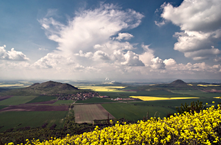
Sky
above České středohoří ( Böhmisches Mittelgebirge) III. Smaller, insignificant cumulonimbus cloud, core of which
evolved above Czech-German borders, near Klínovec mountain. Elongated
anvil of this Cb stretches
eastward, carried by upper-level winds, towards the observation
location. See also this MODIS-Aqua image,
captured at 11:38 UTC (with indication of the place from which the
sequence was captured) and this MSG loop (with the Cb and
time range of the sequence being indicated by red ellipse). Captured
from top of Oblík hill (509 m a.s.l.), district
Louny , Czech Republic, westward view. Satelite data
source: NASA, EUMETSAT and CHMI.
|
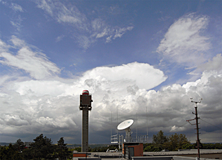 |
2014 - 05 - 13
11:14 - 11:40 UTC (0h 26m)
Ricoh GX100, interval 5 seconds, speed 150x
20140513_1114-1140utc_Libus.mp4
(28 MB, 1496x1080, H.264 / MPEG-4)
20140513_1114-1140utc_Libus.mpg
(13 MB, 1496x1080, MPEG1)
Storm
season begins ... Smaller Cb west of Prague. Captured from roof
of the CHMI Observatory Praha Libuš, Czech Republic (westward view). See also the NOAA-19
image
taken at the beginning of this sequence, when the 3m antenna dish
follows the satellite; red dot indicates the location from which this
sequence was taken. Satellite data source: NOAA and CHMI.
|
 |
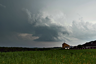
2014 - 06 - 11
12:49 - 14:12 UTC (1h 23m)
Ricoh GXR A16, interval 5 seconds, speed 150x
20140611_1249-1412utc_Okrouhlik_1920x1080.mp4
(73 MB, 1920x1080, H.264 / MPEG-4)
20140611_1249-1412utc_Okrouhlik_1280x720.mp4
(45 MB, 1280x720, H.264 / MPEG-4)
20140611_1249-1412utc_Okrouhlik_1280x720.mpg
(35 MB, 1280x720, MPEG1)
Cb
clouds above northern parts of Bohemia. Captured from Okrouhlík
(Křížkový Újezdec, district Praha-východ, Czech Republic), processed
from DNG files. See also the radar animation (data
source: CHMI) of this case, with location and
time range of this sequence being indicated by a small cross (first
episode there, northward view).
|
 |
2014 - 06 - 11
15:00 - 15:24 UTC (0h 24m)
Ricoh GXR A16, interval 2 seconds, speed 60x
20140611_1500-1524utc_Radejovice.mp4
(32 MB, 1144x760, H.264 / MPEG-4)
20140611_1500-1524utc_Radejovice.mpg
(25 MB, 1144x760, MPEG1)
Inflow
area of a storm.
Two shorter consecutive timelapse series, showing a very active inflow
area of a storm. The storm itself exhibited cell splitting during this
sequence, see the radar
loop (data source: CHMI) for this case, with location and
time range of this sequence being indicated by a small cross (second
episode there, north-east view). Captured from Radějovice, district
Praha-východ, Czech Republic.
|

|
2014 - 07 - 03 20:15 - 21:15 UTC (1h 00m)
Ricoh GXR A16, interval 5 seconds, speed 150x
20140703_2015-2115utc_NLC-Okrouhlik_1920x1080.mp4 (53 MB, 1920x1080
NLC (noctilucnet clouds) above Praha, captured from Okrouhlík
(Křížkový Újezdec, district Praha-východ, Czech Republic), NW view.
This case is to a certain degree exceptional for latitudes of Czech
Republic (~ 50 N) by high altitude of NLC, about 40° to 50° above local
horizon (at the beginning of the sequence). Besides typical appearance
and westward motion of these NLC clouds, high cirrus clouds can be
excluded looking at this MSG-RSS
loop - all cirrus clouds are gone at time of this sequence (and even if
some were left, these would have opposite, south-eastward motion than
NLC, towards the site from which this sequence was taken).
|
 |
2014 - 08 - 10
19:24 - 20:22 UTC (0h 58m)
Ricoh GXR A16, interval 10 seconds, speed 250x
20140810_1924-2022utc_Gosausee-Dachstein_1600x1080.mp4
(37 MB, 1600x1080, H.264 / MPEG-4)
20140810_1924-2022utc_Gosausee-Dachstein_1064x720.mpg
(17 MB, 1064x720, MPEG1)
Moonrise
above Dachstein and Gosausee. Captured on "Blue Moon" evening
from shore of the Vorderer Gosausee, Salzburgerland, Austria.
|
 |
2014 - 08 - 12
13:16 - 16:19 UTC (3h 03m)
Ricoh GX100, interval 10 seconds, speed 300x
20140812_1316-1619utc_Gosausee-Dachstein.mp4
(80 MB, 1064x720, H.264 / MPEG-4)
20140812_1316-1619utc_Gosausee-Dachstein.mpg
(38 MB, 1064x720, MPEG1)
Hidden
Dachstein. Splashing and streaming clouds above Dachstein and
Vorderer Gosausee, Salzburgerland, Austria.
|
 |
2014 - 08 - 17
08:26 - 09:31 UTC (1h 05m)
Ricoh GX100, interval 5 seconds, speed 150x
20140817_0826-0931utc_Gaislachkogel.mp4
(59 MB, 1160x760, H.264 / MPEG-4)
20140817_0826-0931utc_Gaislachkogel.mpg
(28 MB, 1160x760, MPEG1)
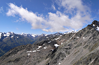
Ötztal
Alps from Gaislachkogel.
Broken cumulus clouds above snow-covered peaks surrounding valley of
Vent. Most of these peaks range high above 3000 m, with the highest of
these, Wildspitze, the highest mountain in the Ötztal
Alps and in Tyrol and the second highest mountain in Austria, reaching
3770 m.
|
 |
2014 - 08 - 18
09:10 - 11:04 UTC (1h 54m), Ricoh GX100, interval 10
seconds, speed 300x
20140818_0910-1104utc_Hohe-Mut_GX100_1760x1080.mp4
(53 MB, 1760x1080, H.264 / MPEG-4)
20140818_0910-1104utc_Hohe-Mut_GX100_1176x720.mpg
(25 MB, 1176x720, MPEG1)
10:23 - 10:56 UTC (0h 23m), Ricoh GXR-A16, interval
3.3 seconds, speed 100x
20140818_1023-1056utc_Hohe-Mut_GXR-A16_1920x1080.mp4
(48 MB, 1920x1080, H.264 / MPEG-4)
20140818_1023-1056utc_Hohe-Mut_GXR-A16_1280x720.mpg
(23 MB, 1280x720, MPEG1)
"Waterfall"
of clouds above peaks of Gurgler Kamm in the
Ötztal Alps. Rotmoosferner glacier rights, and Gaisbergferner
glacier left. Captured from Hohe Mut
Alm (2653 m), Tyrol, Austria.
|
 |
2014 - 10 - 19
10:24 - 10:56 UTC (0h 32m)
Ricoh GX100, interval 2 seconds, speed 60x
20141019_1024-1056utc_Brdy.mp4
(46 MB, 1040x760, H.264 / MPEG-4)
20141019_1024-1056utc_Brdy.mpg
(35 MB, 1040x760, MPEG1)
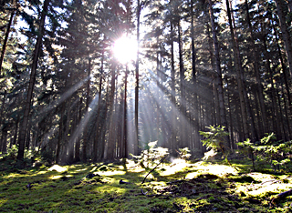
Game
of light and shadows.
Solar rays dancing on remains of morning fog above a small,
moss-covered glade in forests southwest of Praha (Brdy Hills, central
Bohemia, Czech Republic).
|