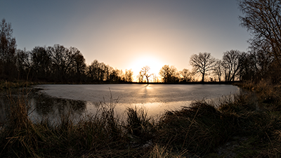
Samsung NX 500 & Samyang 8mm F2.8 UMC Fisheye II, interval 5 seconds, speed 150x
20210225_1544-1637utc_Okrouhlik_1920x1080_H264.mp4 (31 MB)
20210225_1544-1637utc_Okrouhlik_1920x1080_H265.mkv (30 MB, H.265)
Dusty sunset. This timelapse was taken at the end of several days period, when most of the western and central Europe was covered by Sahara dust. First part of the sequence shows clouds of dust traveling roughly eastward, from the Sun to upper left parts of the frame. The thin dust in this sequence can be seen near the Sun only due to stronger forward scattering of the light by very small dust particles. As the frame covers approx. 150° x 100°, the scattering angle near the upper left and right corners reaches about 90°, where the scattering of the solar light is much weaker, and therefore the dust can't be seen here anymore. Later, around the sunset itself, the sky seems to have cleared up already. Captured above partially frozen pond Ovčáry, Okrouhlík, Central Bohemia, Czech Republic.
The dust can be nicely seen also in the M9 band image from VIIRS instrument of the NOAA-20 satellite, taken at 11:25 UTC, or in this image from Meteosat-8 satelite (located above west Indian Ocean), taken in HRV band at 15:30 UTC (shortly before start of the timelapse). Presence of the (Sahara) dust above central Europe is also confirmed by the vertical lidar profile from the CALIPSO satellite, acquired early afternoon (source: NASA LARC).
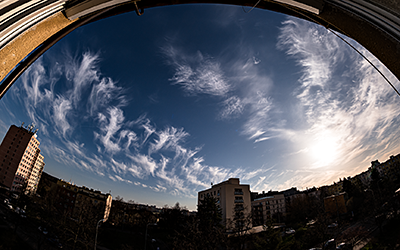
Samsung NX 500 & Samyang 8mm F2.8 UMC Fisheye II, interval 5 seconds, speed 150x
20210331_1548-1808utc_cirrus_Praha-Kacerov_1728x1080_H264.mp4 (120 MB)
20210331_1548-1808utc_cirrus_Praha-Kacerov_1728x1080_H265.mkv (138 MB, H.265)
Evolution of the thin cirrus above Central Europe is here: MSG_CE_VIS-IR
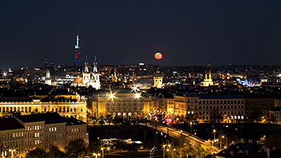
Samsung NX 500 & Asahi Takumar SMC 55mm F2 M42 (set at F5.6), interval 5 seconds, speed 150x
20210427_1730-1930utc_Praha_1920x1080_H264.mp4 (70 MB)
20210427_1730-1930utc_Praha_1920x1080_H265.mkv (71 MB, H.265)
Samsung NX 500 & Samyang 12mm F2.0 NCS CS, interval 5 seconds, speed 150x
20210525_2000-2045utc_NLC_Praha-Vysehrad_1920x1080_H264.mp4 (45 MB)
20210525_2000-2045utc_NLC_Praha-Vysehrad_1920x1080_H265.mkv (58 MB, H.265)
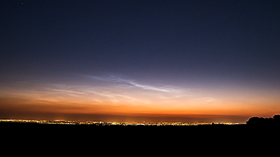
First NLC (noctilucent clouds) of the 2021 season observed from the Czech Republic. Captured from terrace above metro station Vyšehrad, Prague. See also this individually processed image from 20:24 UTC
Onset of the first 2021 north hemisphere NLC: AIM CIPS level 3a daily mosaic loop 19-25 May 2021 (images source: LAPS AIM-CIPS archive) and OSWIN 25 May 2021 profile (source: Leibniz-Institute of Atmospheric Physics, OSWIN VHF Radar).
Samsung NX 500 & Samyang 12mm F2.0 NCS CS, interval 5 seconds, speed 150x
20210618_2030-2113utc_NLC_Okrouhlik_1920x1080_H264.mp4 (43 MB)
20210618_2030-2113utc_NLC_Okrouhlik_1920x1080_H265.mkv (45 MB, H.265)
Samsung NX 500 & Samyang 8mm F2.8 UMC Fisheye II, interval 5 seconds, speed 150x
20210629_1900-1945utc_Kacerov_shelf-cloud_1728x1080_H264.mp4 (42 MB)
20210629_1900-1945utc_Kacerov_shelf-cloud_1728x1080_H265.mkv (40 MB, H.265)
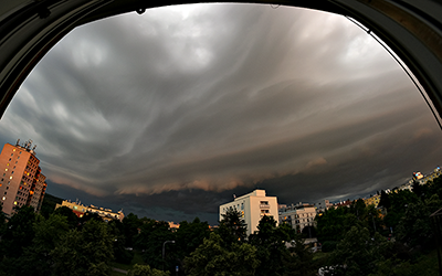
Shelf cloud which formed on the leading edge of evening storms propagating northward. See also this static image from 19:32 UTC. Another timelapse taken from my "Home Office Window" at Kačerov, Prague, Czech Republic, southward fisheye view.
Samsung NX 500 & Samyang 8mm F2.8 UMC Fisheye II, interval 4 seconds, speed 120x
20210713_1752-1855utc_Kacerov_shelf-cloud_1920x1080_H264.mp4 (72 MB)
20210713_1752-1855utc_Kacerov_shelf-cloud_1920x1080_H265.mkv (72 MB, H.265)

Samsung NX 500 & Samyang 8mm F2.8 UMC Fisheye II, interval 3 seconds, speed 30x
20210808_1842-1850utc_Kacerov_1920x1080_H264.mp4 (20 MB)
20210808_1842-1850utc_Kacerov_1920x1080_H265.mkv (19 MB, H.265)
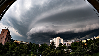
Another shelf cloud taken from my home window at Kačerov, Prague. Very short, but awsome. In this case don't ask me about its interpretation... See also this still image from 18:45 UTC.
Ricoh GXR A16, interval 5 seconds, speed 150x, interval 5 seconds, speed 150x
20210819_0655-0830utc_Rauris_1920x1080_H264.mp4 (82 MB)
20210819_0655-0830utc_Rauris_1920x1080_H265.mkv (84 MB, H.265)
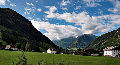
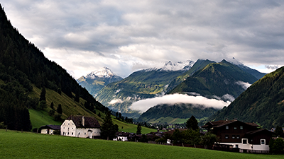
Morning clouds above Raurisertal (Rauris Valley). Captured from balcony of the Appartement Pension Fahrnberggut, Rauris, Salzburgerland, Austria. Southward view.
Samsung NX 500 & Samyang 12mm F2.0 NCS CS, interval 4 seconds, speed 120x
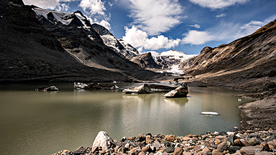
20210821_1107-1241utc_Pasterze-Grossglockner_1920x1080_H264.mp4 (126 MB)
20210821_1107-1241utc_Pasterze-Grossglockner_1920x1080_H265.mkv (122 MB, H.265)
Satellite observations of the glacier from 1985 - 2021. Note that in the folloving images the glacier itself is not only the part which appears as the bright "tongue", much of the glacier is hidden under dark rocks and gravel. To illustrate the real extent of the glacier, its front edge is indicated in this 2015 Sentinel-2 image by red arrows.
- Animated gif showing the difference between years 1991 and 2021, taken by Landsat-5 and Sentinel-2 almost on the same day, 30 years apart.
- Series of satellite images from Landsat-5, Landsat-8 and Sentinel-2, covering period 1985 - 2021, shows the gradual disappearance of the glacier very well.
- Series of satellite images from 2015 - 2021 from Sentinel-2, at somewhat better resolution as compared to the Landsat images.
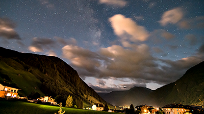
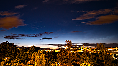
Samsung NX 500 & Samyang 12mm F2.0 NCS CS, interval 20 seconds, speed 600x
20210825_1910-2315utc_Rauris-nocturnal-sky_1920x1080_H264.mp4 (57 MB)
20210825_1910-2315utc_Rauris-nocturnal-sky_1920x1080_H265.mkv (53 MB, H.265)
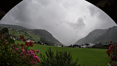
Samsung NX 500 & Samyang 8mm F2.8 UMC Fisheye II, interval 4 seconds, speed 120x
20210826_1308-1530utc_Rauris_1920x1080_H264.mp4 (93 MB)
20210826_1308-1530utc_Rauris_1920x1080_H265.mkv (97 MB, H.265)
Ricoh GXR A16, interval 5 seconds, speed 150x
20210828_0555-0730utc_Rauris_1920x1080_H264.mp4 (82 MB)
20210828_0555-0730utc_Rauris_1920x1080_H265.mkv (81 MB, H.265)
Cloudy morning above Raurisertal, taken on the day of our departure from Rauris. While we were packing home, my Ricoh GXR A16 was timelapsing on the balcony...
Samsung NX 500 & Samyang 8mm F2.8 UMC Fisheye II, interval 8 seconds, speed 240x
20211018_1225-1400utc_Okrouhlik_1800x1080_H264.mp4 (55 MB)
20211018_1225-1400utc_Okrouhlik_1800x1080_H265.mkv (58 MB, H.265)
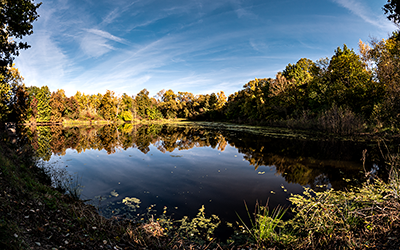
Autumnal reflections. Pond Ovčáry, Okrouhlík, Central Bohemia, Czech Republic.