Samsung NX 500 & Samyang 8mm F2.8 UMC Fisheye II, interval 4 seconds, speed 120x
20190616_0633-0707utc_Asperitas_Kacerov_1920x1080.mp4
(42 MB), ![]()
20190616_0633-0707utc_Asperitas_Kacerov_1920x1080_x265.mkv
(56 MB, H.265)
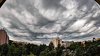
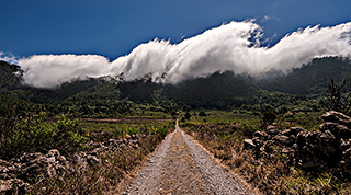
Asperitas, which formed at bottom layers of stratocumulus clouds at about 1.6 - 2 km above ground (see the ceilometer record from Observatory Praha-Libuš, black rectangle marks the time period of the timelapse), after passage of morning showers and weak thunderstorms (radar loop). The turbulent wave motions at the cloud base are most likely a result of very strong wind-shear at these levels (see the soundings wind profile from 06 UTC from Praha-Libuš), which can be nicely seen also in this webcam loop taken from observatory Praha-Libuš (northward view, the red dot indicates the capture time of the timelapse). The timelapse itself was captured from Kačerov, Praha, Czech Republic (southward view, with the observatory Praha-Libuš being located on the horizon, just left of the scene center).
-------------------
More on Asperitas clouds: WMO International Cloud Atlas, UK
Met Office, and paper by Walter A. Lyons.
Samsung NX 500 & Samyang 12mm F2.0 NCS CS, interval 3 seconds, speed 90x
20190621_2032-2055utc_NLC_Praha-Vysehrad_1920x1080.mp4
(38 MB), ![]()
20190621_2032-2055utc_NLC_Praha-Vysehrad_1920x1080_x265.mkv
(53 MB, H.265)
-------------------
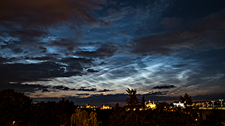
My older NLC cases can be found here:
2009-07-14, 2013-06-27, 2014-07-03, 2015-07-10, 2016-07-05 and 2018-07-02/03

Samsung NX 500 & Samyang 8mm F2.8 UMC Fisheye II, interval 30 seconds, speed 900x
ISO 3200, exposure 25 seconds, F/2.8
20190727-28_1915-0715utc_LaPalma_1680x1080_x264.mp4 (118 MB),
20190727-28_1915-0715utc_LaPalma_1680x1080_x265.mkv (140 MB, H.265)

Samsung NX 500 & Samyang 8mm F2.8 UMC Fisheye II, interval 30 seconds, speed 900x
ISO 3200, exposure 25 seconds, F/2.8
20190731-1900_20190801-0730utc_LaPalma_1680x1080_x264.mp4 (121 MB),
20190731-1900_20190801-0730utc_LaPalma_1680x1080_x265.mkv (155 MB, H.265)
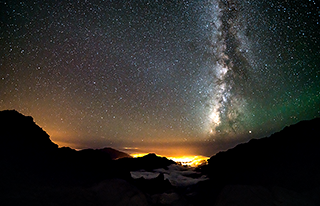
The sky was crystal clear this night, with just a weak haze low above the horizon. Shortly after sunset and just before sunrise, there is a very nice, prominent shadow of the Earth in the sky, including the "Belt of Venus". As it gets dark, at the right side of the frame, a weaker Zodiacal light can be seen for a while. Regarding the visibility of satellites throughout the night, see my comments above.
The most interesting feature of the night was this thin reddish beltlow above the horizon, which appeared as the sky got dark, and was drifting quickly to the south. This thin belt was most likely a wave or bore (?) in the red airglow, emitted by chemiluminescence of hydroxyl radicals, OH* at about 85-90 km levels, near the mesopause. To exclude other possible explanations such as a band of thin clouds or dust, satellite data and atmospheric sounding can be utilized, as shown next. Should the reddish belt be a band of thin clouds or dust, it should appear in these Metop-C RGB images (detail or large image), taken when the belt was still visible in the timelapse, or in this Meteosat RGB NM loop - however nothing corresponding to the feature can be found in these. Taking into account the wind profile (see this midnight Tenerife sounding), southward propagation of the band, and the altitude of the site from which the timelapse was taken, the cloud or dust band would have to be somewhere between 2.5 - 3 km, and thus should be visible even before dusk - which is not the case. The only feature in satellite imagery that resembles the reddish belt by its shape and location, is the feature indicated in this Metop-C IR image by arrows; however, from the MSG IR loop (strongly enhanced IR10.8 band) it is obvious that this feature is stationary, thus it is a sea-surface temperature anomaly. Finally, there is one more argument supporting the airglow nature of the reddish band: should it be a band of clouds haze or dust, the stars behind the band should fade or get blurred behind the band, which is not the case. The SNPP and NOAA-20 satellites with their Day/Night Band (DNB) were of no use in this case, as they passed above the region later after midnight, when the band was already gone. One question remains - what was the mechanism which triggered the wave or bore? Was it the deformation zone near the tropopause, which can be seen north-west of the islands in this MSG WV6.2 loop (the red line indicates very roughly the location and orientation of the reddish band), or some other process in the upper mesosphere, near the mesopause?
Later in the night, part of the sky becomes greenish - a manifestation of green airglow, emitted by atoms of oxygen at about the 90 - 100 km levels. Also, left of the Milky Way (in the smaller image left approx. above the center of the frame) we can faintly see a weak "Gegenschein". Near the end of the night, just before dawn, several dim waves propagating from the bottom left to upper right corners of the frame can be seen - these are atmospheric gravity waves generated by convective storms above northwest Africa.
LaPalma-Canarias_20190726-20190804__x264_1920x1080.mp4 (403 MB)
LaPalma-Canarias_20190726-20190804__x265_1920x1080.mkv (375 MB, H.265)
Part 1: 2019-08-04 13:42-14:57 UTC, Samsung NX500 & Samyang 12mm F2.0 NCS CS, interval 3 s
Part 2: 2019-07-26 13:50-14:50 UTC, Ricoh GXR-A16, interval 5 s
Part 3: 2019-07-29 13:30-14:02 UTC, Samsung NX500 & Samyang 12mm F2.0 NCS CS, interval 3 s
Part 4: 2019-07-26 17:20-18:20 UTC, Ricoh GXR-A16, interval 5 s
Part 5: 2019-07-29 14:50-15:30 UTC, Samsung NX500 & Samyang 12mm F2.0 NCS CS, interval 3 s
Part 6: 2019-07-29 11:42-12:25 UTC, Samsung NX500 & Samyang 12mm F2.0 NCS CS, interval 3 s
Sentinel 2A satellite image: 2019-08-02 12:05 UTC, MSI rgb432; data source: Copernicus Open Access Hub, European Space Agency (ESA), MSI level-1C data processed in ESA SNAP, ENVI and Photoshop software.
Music: Kristina Budzhiashvili - Wind Fantasy, from the album Towards The Sun, 2019, publisher Jamendo, license CC BY-NC 3.0; shortened from the original version.